Three tropical cyclones are churning in the South Pacific — all at once
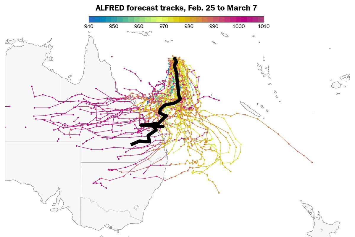
Tropical Cyclone Alfred will probably intensify through the end of the week while tracking toward Queensland, Australia. (Ben Noll/The Washington Post. Source: ECMWF)
For the first time in over 26 years, three tropical cyclones are active simultaneously in the South Pacific.
This vast region, which stretches from the Coral Sea in the west to the Pitcairn Islands in the east, is home to numerous island nations and territories, such as Vanuatu, Fiji and American Samoa. This normally sun-soaked area is now very stormy as cyclones Alfred, Rae and Seru churn in a southerly direction.
Rae caused damage on Taveuni, Fiji’s third-largest island, on Monday local time. Alfred is swirling over the open waters of the Coral Sea and could hit Queensland, Australia, this weekend or early next week, while Seru is intensifying east of Vanuatu.
Tropical cyclones are not unusual for this region, which averages nine named storms per season from November to April. But having three active named storms simultaneously is rare.
The presence of three cyclones is more than just a meteorological oddity. These powerful storms not only can have a dramatic effect on lives and livelihoods in the South Pacific, but they may also have distant impacts on climate patterns that affect the United States. The storms could be indicative of a waning La Niña and warming oceans in the Pacific.
A tropical cyclone trio in the South Pacific
Tropical Cyclones Alfred and Rae formed over the weekend. Then, early Tuesday, Tropical Cyclone Seru formed.
This marks the first time since 1999 that three tropical cyclones are occurring concurrently in the South Pacific Ocean.
Tropical Cyclone Alfred
Alfred is forecast to swirl over ocean water of 83 to 86 degrees in the Coral Sea, west of New Caledonia while potentially intensifying into a Category 2 or 3 storm through the end of the week.
This tropical cyclone could hit central Queensland, Australia, as early as this weekend, probably south of the area near Townsville that experienced 50 inches of rain in just a few days and destructive flooding early this month.
While the exact track of Alfred is uncertain, heavy, flooding rainfall, damaging winds and dangerous seas may occur if it approaches Australia.
Tropical Cyclones Rae and Seru
Rae is moving away from Fiji after causing significant damage in the country’s north on Monday. Locals described villages being “full of debris” and reported crop damage.
Seru formed east of Vanuatu on Tuesday. The worst of the storm is forecast to pass offshore of the island nation, which experienced a severe earthquake in December.
The rarity of three cyclones
To have three tropical cyclones active in any ocean basin is unusual, but particularly rare in the South Pacific.
It has happened only a few times in recent decades, according to data from the International Best Track Archive for Climate Stewardship.
The last time it occurred was in January 1999, when Tropical Cyclones Dani, Olinda and Pete overlapped.
It also happened in 1998 - the most active tropical cyclone season on record in the South Pacific - when Cyclones Katrina, Ron and Susan churned through the region concurrently.
The number of tropical cyclones that form in the South Pacific each season has been trending downward since high-quality observations from satellites began in 1969. Drawing on the seasonal average from 1991 to 2020, there’s about one fewer cyclone per season compared with the average from 1981 to 2010.
“Looking at the recent historical record as a context, the situation we have this week is not common,” said New Zealand-based climate scientist Andrew Lorrey, who researches tropical cyclones. “It’s kind of like drawing the joker out of a deck in a game of cards, but due to the relatively short high-quality historical record, we don’t really know how many cards we’re playing with and how many wild cards like this are typical.”
He added that similar occurrences with numerous active cyclones at once “may have been more common in the past, which is why we need to ramp up efforts to clarify and understand past tropical cyclone activity in this region.”
Part of the reason for the decrease may be linked to the upper atmosphere warming faster than the lower atmosphere. This change contributes to greater atmospheric stability, or an atmosphere less conducive to thunderstorm development.
Thunderstorms are the seedlings for tropical cyclones and hurricanes.
Considering the long-term trend, it may become harder for three concurrent tropical cyclones to form.
What is a tropical cyclone?
A tropical cyclone and a hurricane are the same phenomenon. What they’re called depends on the ocean basin they form in.
In the Atlantic Ocean, these atmospheric heat engines, fueled by ocean water warmer than 80 degrees, are called hurricanes; in the South Pacific islands as well as near Australia and in the Indian Ocean, they’re called tropical cyclones; in the West Pacific Ocean, they’re called typhoons.
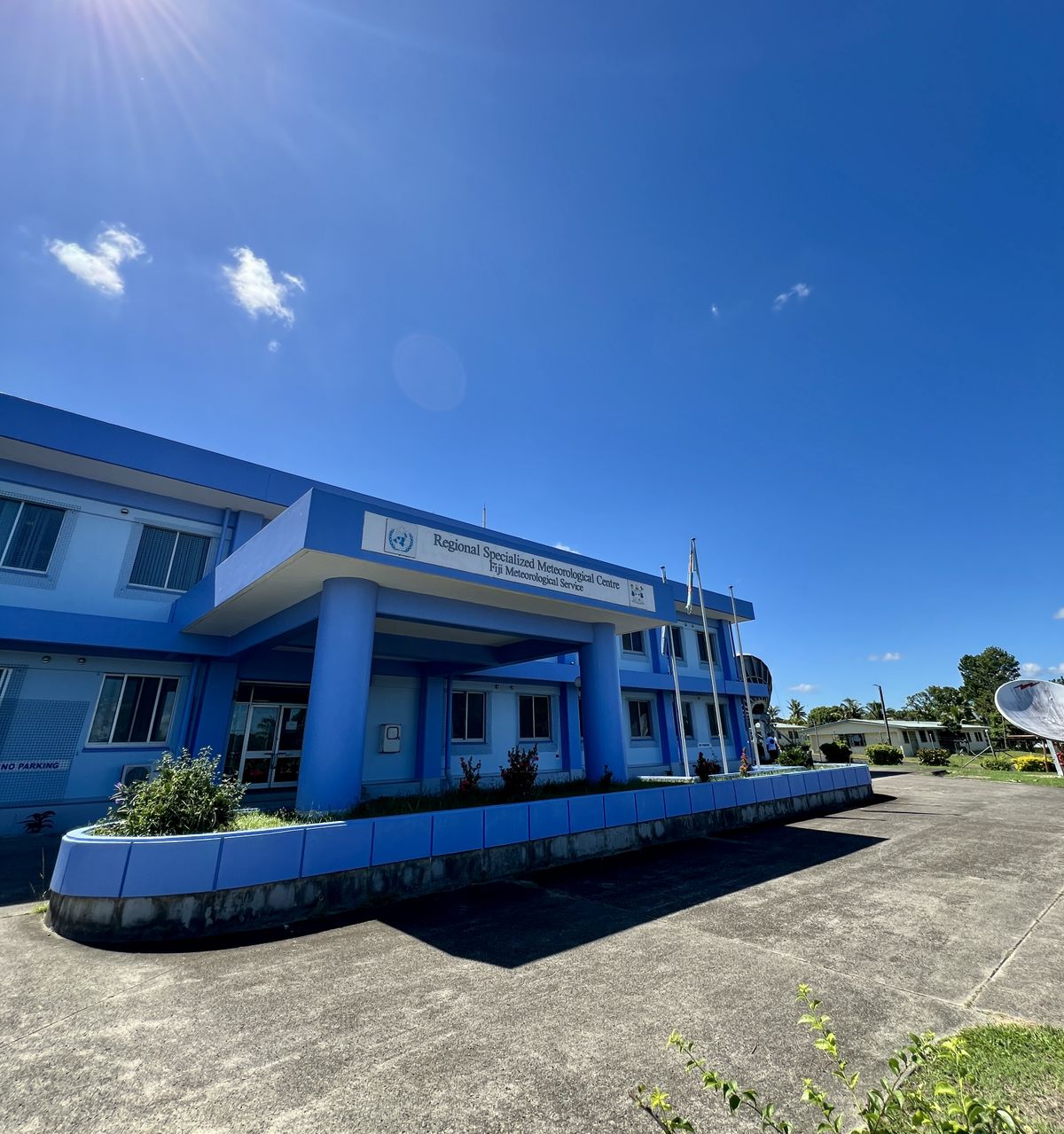
Tropical cyclones are among the costliest natural disasters in the Pacific islands.
That’s one reason representatives from meteorological services and regional institutions across the Pacific gather annually in October at the Pacific Islands Climate Outlook Forum to discuss climate trends for the months ahead.
When cyclones form in the region, storm tracks and information are published by the Fiji Meteorological Service, the New Zealand MetService or the Australian Bureau of Meteorology depending on where the storm is.
Climate impacts for the rest of the world
What happens in the South Pacific, some 8,000 miles from Washington, can influence climate patterns around the world.
The trio of tropical cyclones is associated with a weather pattern that is causing weaker winds in the eastern tropical Pacific Ocean.
Known as trade winds, they play an important role in the development of climatic events such as La Niña and El Niño.
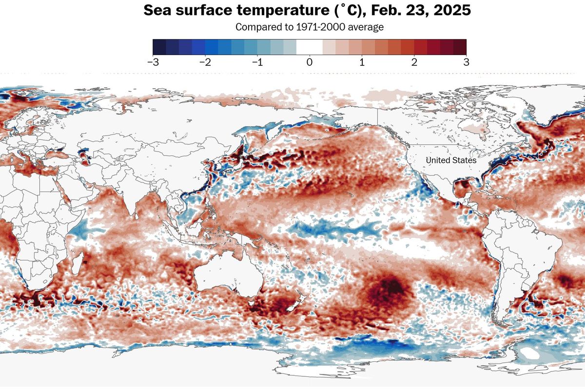
Although the planet is in a La Niña phase, there are signs that pattern may not last for much longer.
Warmer than average ocean water has been pooling in the eastern tropical Pacific - flanked to the west by cooler than average seas. This inconsistent pattern is indicative of the ocean easing away from La Niña.
This is noteworthy because La Niña tends to be associated with more active hurricane seasons in the Atlantic Ocean.
That’s how a distant trio of tropical cyclones may be playing an early role in helping to shape the drivers of the 2025 hurricane season, which begins June 1.