Polar vortex will bring frigid air back to many states after weekend storm


People walk on a wooded trail in Springfield, Virginia, on Wednesday. A storm brought significant snowfall to the region. (Matt McClain/The Washington Post)
The polar vortex is coming back. After a half-month hiatus, frigid air will again surge across the United States beginning this weekend through next week, as the unusually cold blob of air dips southward, covering various parts of the country by Tuesday.
Ushering in the vortex is a winter storm, the third one of the week, which will track from the Intermountain West on Friday to the East Coast on Sunday.
The storm will bring accumulating snow or ice to around a dozen states, flooding to the Tennessee and Ohio valleys and a severe line of thunderstorms to the Deep South. From there, the vortex will bring dangerously cold, subzero temperatures to more than 80 million people across the United States through next week.
After the weekend storm, yet another system may dump snow in the central and eastern states from Tuesday to Thursday.
Where the weekend storm will hit hardest
On the cold side of the storm, snow will fall across parts of the Intermountain West, Plains and Midwest on Friday, then the Midwest and Northeast over the weekend.
Flooding rain and severe thunderstorms are possible on the warm side of the storm, including the Tennessee and Ohio valleys and the Deep South.
Here’s what to know:
Snow and ice
- Advisories and warnings for snow cover the Intermountain West as of early Friday, with the areas around the following cities expecting some accumulation through Saturday: Reno, Nevada; Flagstaff, Arizona; Salt Lake City; Boise, Idaho; Denver.
- The following places east of the Rocky Mountains can expect accumulating snow and/or ice this weekend: North Dakota, South Dakota, Nebraska, Kansas, Missouri, Iowa, Minnesota, Wisconsin, Illinois, Indiana, Michigan, Ohio, northern Kentucky, western North Carolina, western Virginia, West Virginia, western Maryland, Pennsylvania, northern New Jersey, New York, Connecticut, Rhode Island, Vermont, New Hampshire and Maine.
- The heaviest snow will fall in northern New York and northern New England, where amounts will exceed six inches, while substantial icing is possible in New York and New England.
Heavy rain
- A slow-moving area of heavy rain and thunderstorms is forecast to extend from Arkansas to West Virginia from Saturday into early Sunday, also affecting southeastern Missouri, western Tennessee, northern and western Kentucky, southern Indiana and southern Ohio.
- The National Oceanic and Atmospheric Administration’s Weather Prediction Center has issued a moderate (Level 3 out of 4) risk for excessive rainfall in these areas.
Severe thunderstorms
- A line of strong to severe thunderstorms is forecast to develop over eastern Texas on Saturday afternoon before tracking across Arkansas, Louisiana, Mississippi, Alabama, Georgia and Tennessee from the evening through the night.
- Some severe thunderstorm cells within the line will be capable of producing tornadoes, with NOAA’s Storm Prediction Center issuing an enhanced risk (Level 3 out of 5).
The Gulf of Mexico remains warmer than average, which will provide extra fuel to the weekend storm and potentially another one next week.
Polar vortex, the sequel
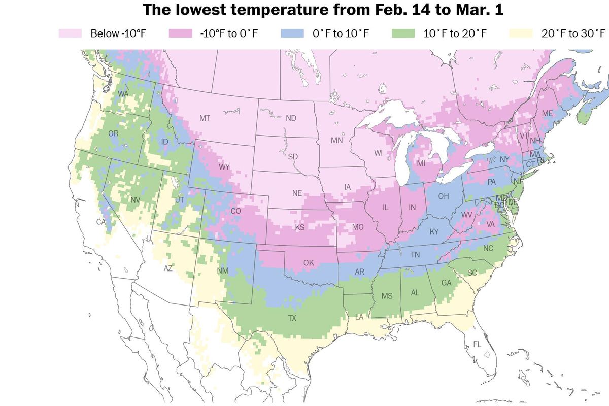
Around 105 million people in the United States experienced subzero temperatures during the first polar vortex episode in January.
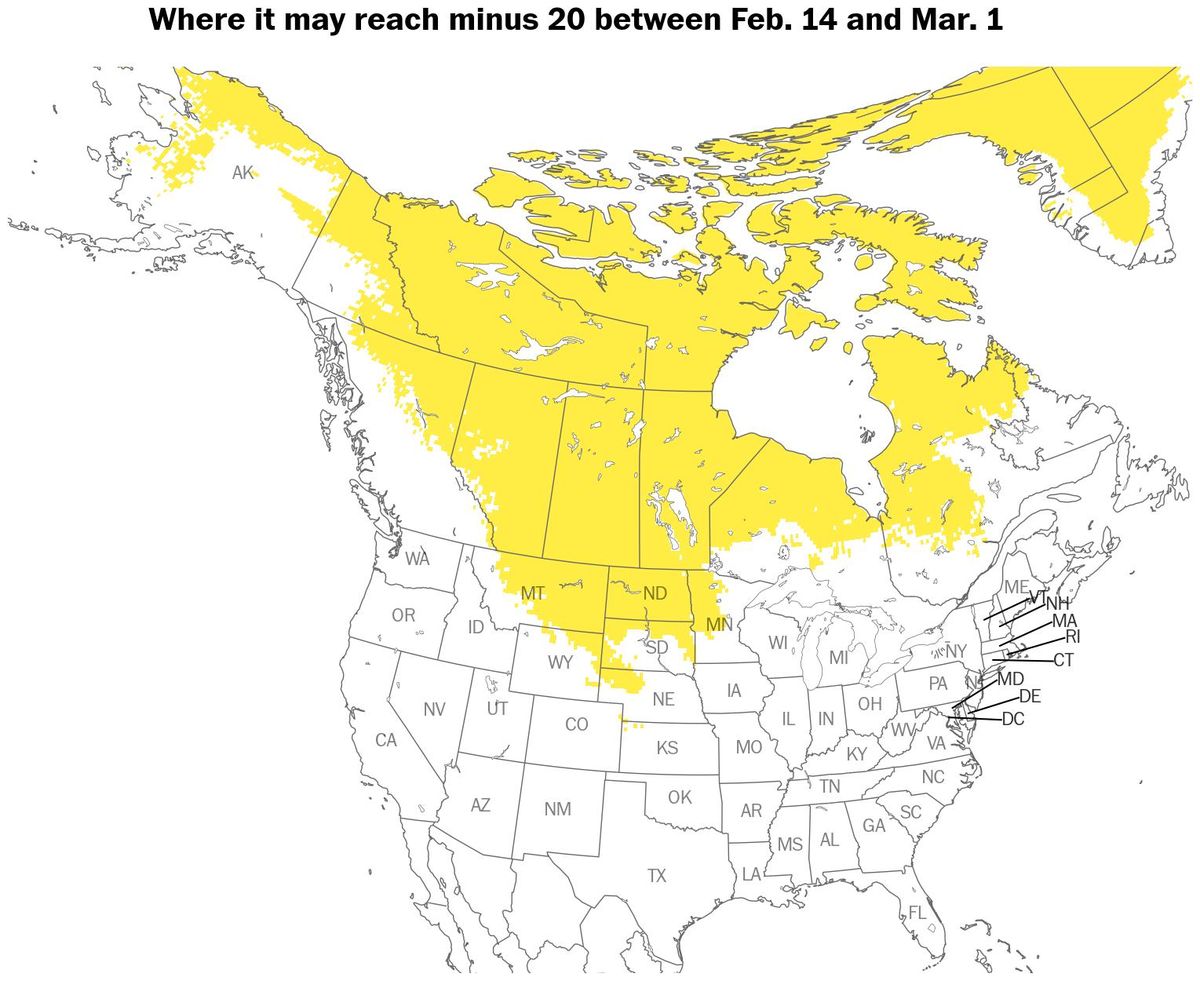
Now, the pattern is returning: More than 80 million people across the country are forecast to experience subzero temperatures through the end of February.
The brutal cold will be first felt in the Rockies and Plains on Saturday, the Midwest on Sunday and the East Coast on Monday.
Throughout next week, the most unusually cold air on the planet will be centered over the United States.
From Tuesday through Thursday, parts of more than two dozen states could experience subzero temperatures, from Montana to Maine and potentially as far south as northern Texas - whose power grid was bolstered after deadly cold in February 2021.
The frigid conditions will spur the development of lake-effect snow bands, such as in New York’s Tug Hill Plateau, which has received the most snow east of the Rocky Mountains so far this winter - around 336 inches.
When gusty wind is factored in, frostbite times of less than 20 minutes could pose a threat to people and pets.
The most extreme conditions are forecast in Montana and North Dakota, where readings of minus-40 are possible. The lowest temperature ever recorded in North Dakota is minus-60 during January 1936, while Montana owns the record for the lowest temperature observed in the contiguous United States: minus-70 at Rogers Pass near Helena in January 1954.
Through the middle of next week, the most frigid conditions are forecast in the central states as a possible winter storm gathers to the east. While it’s not set in stone, some weather models suggest that temperatures may dip to minus-20 in Kansas on Thursday - almost 50 degrees below average for the time of year.
By the end of the week, the icy air may again reach the East.
The polar plunge is being driven by a feature called a Greenland block.
A Greenland block refers to a strong high-pressure system that extends up through the atmosphere over Greenland and the surrounding Arctic, anchoring unusually warm conditions there for an extended period - up to 40 degrees above average.
The cold air typically found over the region becomes displaced and is forced to move around the atmospheric block. In this case, it will surge southward through Canada and into the United States.
Temperatures will probably return to seasonable levels during the week of Feb. 24.
Could another storm form next week?
As the cold air associated with the polar vortex clashes with warmer air from the Gulf of Mexico, a storm may form in the central states Tuesday.
Areas from Texas to the Carolinas should be on alert for the potential for wintry precipitation next week, although specific forecast details won’t be known for a few more days.
Depending on its track, the storm may also bring snow to the Ohio Valley, Midwest, Mid-Atlantic and Northeast on Wednesday and Thursday.
Because there will be plenty of cold air in place due to the polar vortex, the storm may have a relatively high ceiling for possible snowfall totals.
Temperatures later next week may turn out coldest in places that have a deep, fresh snow pack, which acts as a natural refrigerator.
In other words, keep the shovel, snowblower, hat, gloves and scarf handy.