Potentially catastrophic flooding and tornado threats in central U.S.
MEMPHIS, Tennessee – Strong and warm winds of up to 50 mph gusted in from the south, causing thousands across southwestern Tennessee to lose electricity Wednesday afternoon, the first rumblings of the major storm poised to inundate millions in the Mid-South with heavy rain through Saturday.
Ahead of the anticipated deluge, all appeared normal in this city, even as local officials warned of tornadoes and flooding. Outdoor furniture, traffic cones and road signs remained outside. A handful of tourists snapped photos of the neon signs of Beale Street, known as the home of the blues. Construction continued even as the first bursts of heavy rain began passing through, interrupted by pockets of sunshine that pushed temperatures into the 80s and increased atmospheric instability ahead of the coming storms.
It was the quiet before the potentially catastrophic and life-threatening extreme weather event expected to affect more than 40 million people across the country, as national weather officials issued rare high-level warnings and states began to take action.
Kentucky Gov. Andy Beshear declared a state of emergency Wednesday, urging residents to take the storm seriously. “We’re under some of the most serious weather threats I’ve seen,” he said in a statement.
A high risk for excessive rainfall – the highest level that the National Oceanic and Atmospheric Administration issues – covered parts of five states from Thursday into Friday, with the Weather Prediction Center calling the event an “extreme flooding scenario” because of its multiday nature. And some areas in the central and Mid-South region that could get hit by tornadoes may be in flood zones in the coming days.
The National Weather Service in Little Rock wrote that “extensive, rare and at times catastrophic flash flooding is likely if forecast rainfall totals are realized” and that “flash floodwater levels may reach areas that rarely or have never flooded before.”
“The forecast heavy rainfall in this event has a return interval of anywhere from 25 to 100 years,” the office wrote.
Up to three Aprils’ worth of rain may fall in a matter of days, with widespread rainfall amounts of 6 to 12 inches from northeastern Texas to southwestern Ohio by Sunday. Rainfall amounts in the hardest-hit places will probably exceed a foot, causing river and roadway flooding, with concerns for some of the flooding to develop quickly.
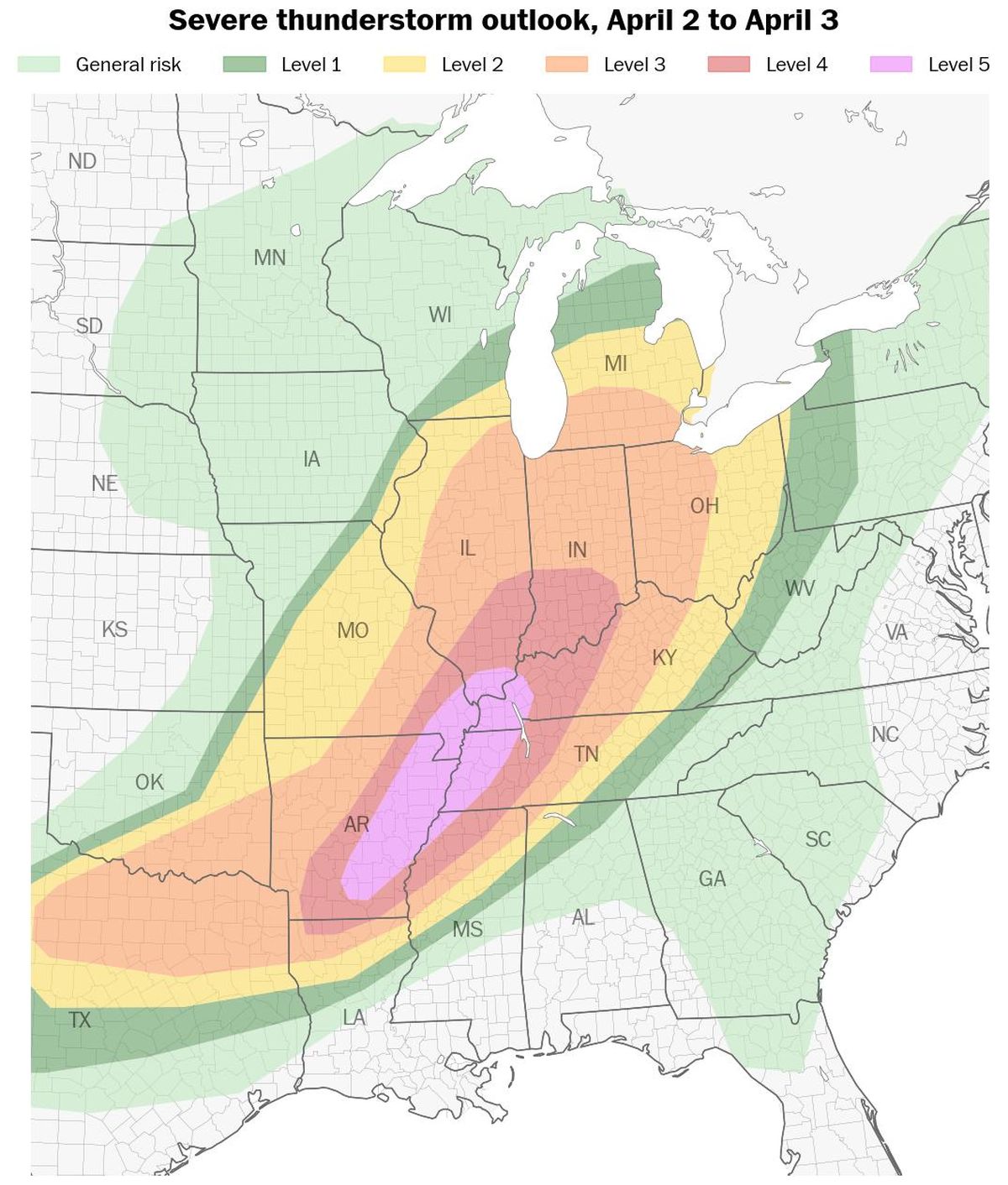
NOAA has also issued its highest warning level for severe thunderstorms on Wednesday, with a Level 5 out of 5 spanning six states and over 2.5 million people across the Mid-South. The potential exists for numerous tornadoes, some of which are likely to be strong and long-track, rotating for dozens of miles.
The storm that brought tornadoes, large hail and damaging winds to the Plains on Tuesday will track eastward Wednesday.
The storm will tap into a tropical moisture plume streaming up into the Mississippi Valley, where a corridor of intense rain and severe thunderstorms will develop Wednesday afternoon, lasting through the night.
Because of the storm’s slow-moving and heavy nature, flash flooding is a serious risk for a large area extending from southern Arkansas to southern Indiana, including urban centers such as Little Rock, Memphis, Nashville and Louisville – a metro area home to more than 7 million people.
Up to 8 inches of rain could fall in the hardest-hit areas by Thursday morning.
From Thursday into Friday, a second surge of tropical moisture will move across a similar region, when a high risk (Level 4 out of 4) for excessive rainfall comes into effect for parts of northeastern Arkansas, northwestern Tennessee, southwestern Kentucky and far southeastern Missouri.
The risk for extreme rainfall will then shift westward from Friday into Saturday, expanding to include northeastern Texas, eastern Oklahoma, the rest of Arkansas and larger parts of Missouri and Illinois.
Late Saturday into early Sunday, a final surge of intense rain is possible in the same areas that will be hit hardest from Wednesday into Thursday, meaning that some communities could be affected by multiple rounds of flooding in the days ahead.
More than a foot of rain could fall in some places by early Sunday.
“This setup is shaping up to be a more extreme flooding scenario considering the multiday prospects,” the Weather Prediction Center wrote.
Threats of tornadoes
A tornado outbreak is expected Wednesday and Wednesday night across the mid-Mississippi and lower Ohio Valleys, with NOAA’s Storm Prediction Center warning about the potential for strong and long-track tornadoes.
The center issued a rare high risk for severe thunderstorms – the highest level on its scale – early Wednesday.
Supercell thunderstorms capable of producing tornadoes are forecast to develop during the mid- to late afternoon Wednesday, with the risk continuing into the night.
Little Rock officials told residents tornado sirens would go off if danger was near. “Pack a small backpack with water, medications, and important documents. Have a plan for where you’ll take cover if severe weather strikes,” the city wrote on its social media pages.
More than 40 million people live in an area that has at least an enhanced risk for severe storms from Wednesday to early Thursday, stretching from Dallas to near Detroit, where damaging winds and large hail will accompany the tornado threat.
More than 2.5 million people live in the area with the highest risk for tornadoes, which includes Memphis and Jonesboro, Arkansas.
Areas with the potential for flooding rainfall overlap with those that could experience strong tornadoes.
Beyond the immediate threat of flooding and thunderstorms, winter storm warnings covered parts of three states – North Dakota, South Dakota and Minnesota – as of early Wednesday.
The combination of heavy, wet snow and strong gusts through Wednesday night will cause whiteout conditions and bring a chance for downed trees and power outages.
In the hardest-hit areas, more than a foot of snow may fall.
A wintry mix will also affect northern New York and interior New England from late Wednesday into Thursday, leading to dangerous travel conditions in northern New York, Vermont, New Hampshire and Maine.