The tiny town of Marshall is grappling with the legal implications of a mysterious new lake

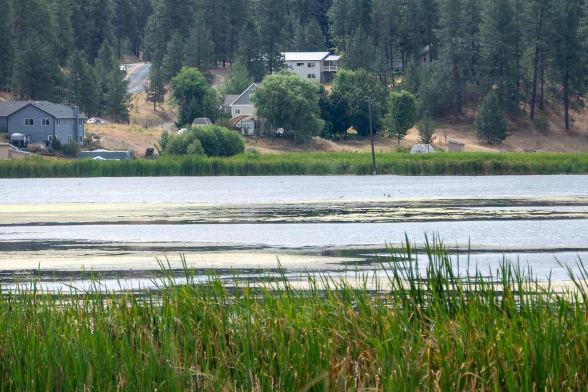

Once drained by an enterprising farmer who dug a drainage outlet many decades ago to make the land farmable, Marshall Lake has filled up again and is offering surrounding homeowners waterfront property and a haven for wildlife, shown Tuesday, July 30, 2024. Marshall is a small unincorporated town south of Spokane and east of Cheney.
New lakefront property has appeared southwest of Spokane. But it’s not necessarily the homes that are new – it’s the lake.
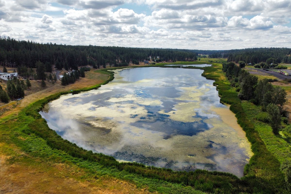
Since 2017, the residents of tiny Marshall have watched as 45 acres of rich wheat land began to transform into a wetland. Today, the locals call the flooded field along Gardner Road, replete with cattails, ducks and algae, Marshall Lake.
Following the idyllic Marshall Creek as it winds along yards, between fields and fences, and along railroad tracks building a long ecosystem, it’s hard to recognize any problems.
During the summer, up to 25% of the creek is used by locals for irrigation, to feed ponds and wells. It is home to abundant wildlife, according to the Spokane Conservation District.
The creek is a tributary of the larger Latah Creek, which, eventually, feeds the Spokane River below Browne’s Addition. Most of the creek’s water, however, is now feeding the lake – leaving locals and wildlife alike with dry creek beds.
Since 2017, at least 2.5 miles of the creek have become dry, which is affecting everything from the region’s wildlife to senior water rights, domestic wells and local fisheries, according to the conservation district.
Local resident Gale Fowler remembers when the creek housed abundant wildlife, including fish, crawdads and even otters. In past winters, he recalls the creek flooding his pasture and his grandchildren ice skating on its surface.
His porch overlooks a winding portion of the creek, its soft gurgling heard between the rumbles of train cars in the distance.
He points to a rocky berm, a foot or so above the creek bed – the depth the creek used to have.
Fowler has lived along Marshall Creek since 1988. As the senior water rights holder in the area, he has the right to use the most water from the creek. He noticed the creek drying in June 2017, so he and his neighbors contacted local agencies, looking for help.
“They shrugged their shoulders and told us it was climate change,” he said.
Fowler and his neighbors also noticed the nearby wheat field flooding. According to Fowler, that was not uncommon – in fact, according to local authorities, the field’s owner had to periodically drain the property to use it for growing wheat and grazing livestock.
But as years progressed, the problem didn’t go away. The field has become a lake, and the creek’s flow kept slowing.
“It’s a crisis,” Fowler said.
Jaime Short, the Eastern Section Manager for the Washington Department of Ecology’s Water Resources program, recalls receiving messages from the Marshall community in 2017 and 2018.
A subsequent investigation found that “there had been some sort of breach that occurred” in the stream, “and it started to fill up what was probably, historically, a wetland area,” according to Short.
The issue, she said, was that for the Department of Ecology, “there wasn’t an action that the water resources program could take.”
Short detailed how, when the breach first occurred, landowners were frustrated – “they kept waiting for someone to come.”
But the water resources program, which protects landowners’ water rights, had no regulatory authority to fix the issue, nor did the Department of Fish and Wildlife or the Department of Natural Resources, according to Short.
It was only in 2023, when the Spokane Conservation District was contacted about the issue, that an agency began making an effort to solve the issue of a filling lake and a drying creek.
Walt Edelen has been the water resources manager at the conservation district for more than 25 years and has been working on the Marshall Creek project since 2023. Many in the community credit him as the leader of the project.
The polished, six-pointed badge on his orange high-visibility vest proclaims him a Junior Forest Ranger – “I’m not quite certified enough to be a full one,” he quipped.
Edelen and the conservation district take monthly water discharge measurements at various points of the creek – including a portion on Fowler’s property.
Edelen doesn’t think Fowler’s portion of the creek will make it much longer.
“I’d like to say we can fix it by a certain date, but there are just too many unknowns,” Edelen said.
The conservation district has measured the creek’s flow at 14 locations since September. It measures the flow and temperature of the water. At one spot, the creek flow has gone from 0.94 cubic feet per second to 0.55.
The temperature, meanwhile, has risen almost 10 degrees, from 63 to 72.5 degrees Fahrenheit.
Dynamite, flowers and finally, wheat
According to Edelen, historic maps of the area show the now-flooded field as a body of water. At some point in the 1930s or ’40s, the portion of the creek that runs through the field was straightened by a landowner, and the railroad installed a gravel berm for tracks to sit on that intersected with the creek.
The field was home to Broadview Dairy factory, four dynamite factories and a greenhouse, which supplied flowers for the Davenport Hotel, according to locals.
Later, the field for decades was used for hay and cattle, Edelen said. At some point, the field property was foreclosed, and the county divided and sold it.
The field was not drained. Around the same time, the railroad removed the gravel berm, allowing water to flow freely.
Some locals point toward the fact that the stream was artificially straightened, and that the field is simply returning to its natural state.
Bev Keating has lived in the area since 1973 and has been involved with efforts to restore the creek for decades.
In the 1990s, Keating was involved in the Marshall Creek Coalition, a group that worked to improve the streams’ flow.
The Spokesman-Review reported on the coalition’s efforts three times from 1992 to 1994 as Marshall Creek was not reaching its confluence with Latah Creek – though, at the time, it was due to irrigation and drought, not the natural filling of a field.
“Several people call (it) Marshall Lake,” she said. “I call it a flooded field.”
Keating, who has water rights for a portion of the creek near Fowler, said the creek is less than 2 inches deep. She remembers her children water tubing down the same water.
Keating has rights to use the creek to fill a pond and to irrigate her yard, both of which she is unable to do. She remembers blue heron, otters and kingfishers along the creek. Now there’s nothing.
“It’s really sad when you see vegetation that’s grown here for 40, 50 years die because there’s no water,” Keating said.
Today, many people with houses in the area have a scenic view of the new lake with a water depth of about 6 feet.
One property owner, Beau Tinkham, moved to the area in March 2022. He and his wife bought property where the creek disperses into the lake.
There was no formal mention of the lake in the property’s listing, Tinkham said, and maps don’t identify the body of water. Still, today there is no formal mention of the water in maps. It wasn’t until he met the former property owner’s son that he learned the property had flooded.
“I had suspicions there was something odd about it, but I didn’t know otherwise,” he said.
Some claim that after the field flooded, property in the area was advertised as “waterfront,” though Tinkham said neither his nor his neighbors’ property was sold as such.
The previous owner of Tinkham’s property, who saw the flooding in 2017, moved, Tinkham said, because of harassment they were experiencing from the community, blaming them for the creek’s diminished flow.
Tinkham said he has experienced some of the same as people downstream blame him for water use restrictions and diminished property values. Some told him to drain the lake.
These contrasting experiences initially led to animosity within the community – the waterfront owners, who don’t want to lose the lake, and water rights owners, like Keating, whose legal rights are being affected by the creation of the lake.
“The thing is, we all want water,” Tinkham said. “I don’t think any of us who live on the lake want to see the lake go away.”
Tinkham’s property, he said, was in a derelict state when he bought it. He and his wife have taken “tons” of garbage off the property.
“The only reason we took that on was because the water was adjacent to it,” he said.
The Spokane Conservation District didn’t get involved at the lake for a year after Tinkham moved to the area.
Before that, he said, “(The lake) was always shuffled from one department or one agency to the next, being somebody else’s problem – so nobody would ever take it on.”
Since the conservation district has been involved, Tinkham said, the animosity within the community has lessened.
“You’re never going to please everybody, and I’m not trying to,” Edelen said.
Last October, the conservation district held a public meeting attended by more than 70 residents and formed the Marshall Creek Advisory Work Group. Both Fowler and Tinkham are members.
“We’ve tried to approach this with an open mind,” Tinkham said, “but always with the approach that we want to better understand what the situation is and what the options are moving forward.
“There’s a lot more to it than the lake showing up. The lake was just the symptom that brought everybody’s attention to it.”
Edelen recalls the October meeting as a turning point in the community: “You can be adversarial, but when you sit down, and you realize that you all want the same thing. … They’re all people. They all have the same values.”
Since then, Marshall Creek has become a community project. Short recalls the first “quasimeeting” she attended, which took place in a local’s living room.
“I have participated in a number of planning efforts, efforts around water, and this is the first one I’ve participated in that really was from the ground up,” she said.
The priority now, Edelen said, is to restore Marshall Creek’s flow so it reaches Latah Creek. The SCD, in October, proposed a feasibility study, to better understand current hydrology, hydrogeology and land use changes in the area – the outcome of that study, he said, will determine the path forward.
“But until that analysis is performed,” Short said, “it’s just throwing darts at a board.”
It will be a long process, and the conservation district has applied for a grant from the Department of Ecology to fund the feasibility study. The district will find out this fall whether it received the grant.
Even if the grant is awarded, a study could take months, followed by years to implement something of this scale, Edelen said.
When the feasibility study is complete, it will be the work group that decides what to do next.
Ultimately, officials agree the lake is unlikely to go away.
Rather, the community will need to find something ecologically and legally sustainable that satisfies everybody.
“This could have gone a litigious route; that’s expensive, sets neighbor against neighbor,” Short said. “The approach that the Marshall Creek community is taking is the alternative.
“It’s working together. It’s acknowledging that what I do affects you, and we both have a vested interest in coming together and trying to do this right.”