Hurricane Beryl explodes to Category 5 on path toward Jamaica and Cancun
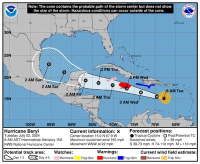
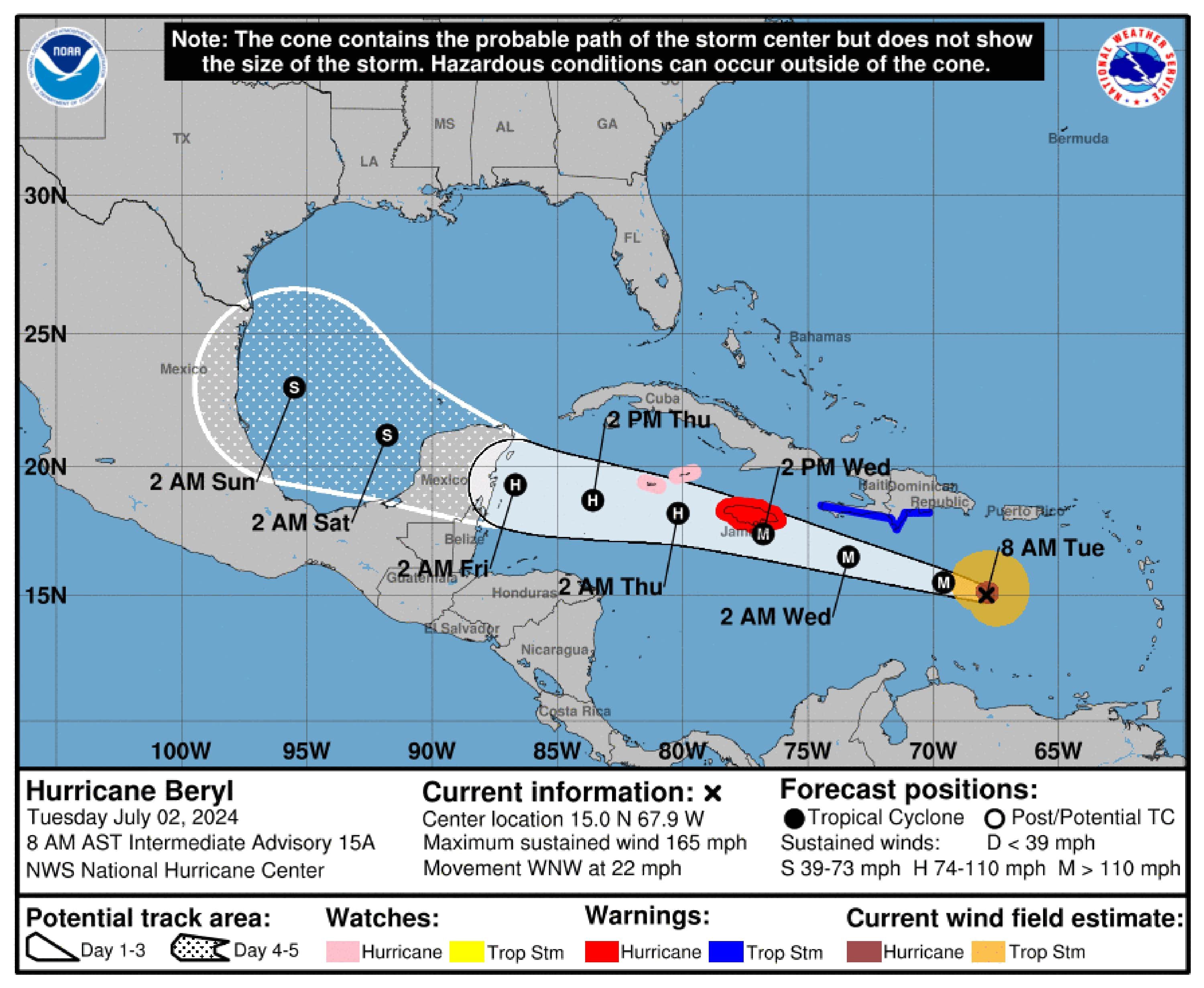
FORT LAUDARDELE, Fla. – Hurricane Beryl continued to rapidly intensify on Tuesday morning, reaching a powerful Category 5 hurricane before downgrading to a 4 with maximum sustained winds of 150 mph, the National Hurricane Center said.
“Life-threatening” winds and potentially 5 to 8 feet of storm surge are forecast to strike Jamaica on Wednesday, despite some potential weakening during the day on Tuesday.
Beryl is forecast to bring 4 to 8 inches to Jamaica Wednesday, with up to 1 foot in localized areas.
Haiti and the Dominican Republic are not in the direct path of Beryl, but the storm is close enough to bring a potential storm surge of 1 to 3 feet along the southern coasts, the hurricane center said. Tropical storm conditions are forecast to arrive in Haiti and the Dominican Republic Tuesday, while the Cayman Islands will experience hurricane conditions.
Southern areas of Haiti and the Dominican Republic will be impacted by Beryl’s outer bands Tuesday into Wednesday, with 2 to 6 inches of rain possible.
On Tuesday night, the storm was located about 360 miles east-southeast of Kingston, Jamaica
. The hurricane had top winds of 150 mph and was moving west-northwest at 22 mph .
All of Jamaica and parts of Mexico and Belize were within Beryl’s cone Tuesday. Jamaica has issued a hurricane warning and hurricane conditions are possible there by Wednesday.
Grand Cayman, Little Cayman and Cayman Brac were under a hurricane watch Tuesday.
A tropical storm warning is in effect for the Dominican Republic from Punta Palenque west to the border with Haiti and the entire south coast of Haiti from the border of the Dominican Republic to Anse d’Hainault.
“Development this far east in late June is unusual,” the forecasters at the hurricane center said. “In fact, there have only been a few storms in history that have formed over the central or eastern tropical Atlantic this early in the year.”
“Beryl is the easternmost hurricane and ‘major hurricane’ to form in the tropical Atlantic during the month of June,” the Weather Channel reported.
It is not expected to affect South Florida, but should pass Jamaica on Wednesday and reach Mexico’s Yucatan Peninsula by Friday.
Once the storm crosses the Yucatan and is over water once again, it will be weaker, but its potential path broadens, and could include Southern Texas.
Forecasters also said that a tropical wave, located about 1,000 miles east of the Windward Islands in the Atlantic on Monday, could become a tropical depression by midweek as it moves toward the eastern and central Caribbean.
It has a 20% chance of developing in the next two days and a 30% chance in the next seven days as of 2 a.m. Tuesday.
It is expected to move west at 15 mph to 20 mph, forecasters said.
The next storm to form would be Debby.
The western Gulf of Mexico generated the 2024 season’s first tropical storm last week. Dubbed Alberto, the system made landfall in Mexico 250 miles south of the U.S. border, but sent storm surge and flood to spots 500 miles away in Louisiana.
The 2024 hurricane season, which officially began June 1, is expected to be extremely active.
In its annual May outlook, the National Oceanic and Atmospheric Administration said that the 2024 hurricane season has an 85% chance of being above normal, with 17 to 25 named storms with minimum sustained winds of 39 mph, and eight to 13 hurricanes. An average year has 14 named storms and seven hurricanes.
In addition, NOAA has forecast four to seven major hurricanes for 2024, meaning those that are Category 3 or above.
Experts at Colorado State University stated in their 2024 forecast that the U.S. East Coast, including Florida, had a 34% chance of a major hurricane making landfall this year. The average from 1880-2020 was 21%.
Forecasters say that the record-warm water temperatures that now cover much of the Atlantic Ocean will continue into peak hurricane season from August to October. That warm water fuels hurricanes. By early June, the tropical Atlantic was already as hot as it usually is in mid-August – peak hurricane season.
Hurricane season officially ends Nov. 30.
“I am encouraging all Jamaicans to take the hurricane as a serious threat,” Prime Minister Andrew Holness said in a public address late Monday. “It is, however, not a time to panic.”