Tropical Storm Tammy forecast to be a hurricane by Monday

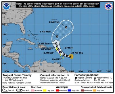
Tropical Storm Tammy is expected to be at near-hurricane strength this weekend, intensifying to hurricane strength by Monday, according to the latest forecast.
National Hurricane Center forecasters expect Tammy to gradually strengthen thanks to very warm water temperatures despite facing some dry air and wind shear. Tammy’s wind speeds are expected to reach 70 mph by Sunday and 80 mph by Monday. If its maximum sustained winds reach 74 mph or above, Tammy would be a hurricane.
Tammy is on track to pass over some of the islands in the eastern Caribbean before turning northwest away from land.
As of 5 a.m. Thursday, Tammy’s maximum sustained winds were holding steady at 40 mph, with its tropical-storm-force winds extending outward up to 140 miles from its center. By 7:30 a.m., Tammy’s top winds had spiked to 60 mph.
As of 8 a.m., Tammy was located 465 miles east-southeast of Guadeloupe, traveling west at 16 mph.
Tropical storm watches were issued for many islands including Barbados, Dominica, Martinique, Guadeloupe, Antigua, Barbuda, Montserrat, St. Kitts, and Nevis, where tropical storm conditions could begin Friday. Large and potentially dangerous swells from Tammy will start hitting the eastern Caribbean on Thursday.
Rainfall totals could reach 3 to 6 inches, with maximum amounts of 10 inches in the islands of the eastern Caribbean, with rain of 1 to 2 inches with maximum amounts of 4 inches in the British and U.S. Virgin Islands and eastern Puerto Rico. Mudslides and isolated flash and urban flooding are possible.
The storm is expected to curve westward on Thursday and move more slowly, then turn northwest on Friday or Saturday and pass over or near the Leeward Islands in the far eastern Caribbean.
The current forecast and models have the system eventually curving northwest away from Florida, but the islands of the far eastern Caribbean, such as the Lesser Antilles, could be affected.
“After Tammy passes the Leeward Islands, the intensity models suggest that some further intensification will be possible as it accelerates northeastward over the central Atlantic,” the latest forecast discussion said.
So far this season in the Atlantic, there have been 19 named storms, six of which were hurricanes. Of those, three were major hurricanes, meaning Category 3 or above.
Those were Hurricane Lee, a rare Category 5; Hurricane Franklin, a Category 4; and Hurricane Idalia, which made landfall on Florida’s Big Bend region at Category 3 strength on Aug. 30.
The remaining storm names for 2023 are Vince and Whitney. If all those names end up being used this season, the National Hurricane Center would turn to the supplemental list of names from the World Meteorological Association. In previous years, the Greek alphabet was used for additional storm names — which had only happened twice before — during the record-shattering hurricane seasons in 2005 and 2020.
Hurricane season officially runs through Nov. 30.