Getting There: North Spokane Corridor work gets underway to span Spokane River
At the beginning of the year, amid a back-and-forth in Olympia over budget priorities, it wasn’t clear if the North Spokane Corridor linking Interstate 90 to Wandermere would be completed this decade.
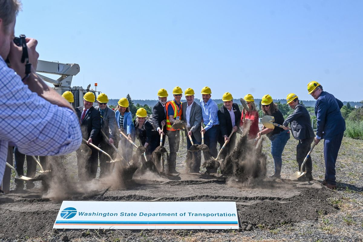
With the freeway’s funding and construction schedule back on track, the state Department of Transportation has broken ground on the section of the north-south corridor that will span the Spokane River near Spokane Community College. It is the shortest section of the 10.5-mile, decadeslong project and one of the most expensive, with a price tag of $91 million.
The Tuesday groundbreaking included remarks from WSDOT officials, six state legislators, two county commissioners and others, including Spokane Mayor Nadine Woodward and City Council President Breean Beggs. In opening remarks, WSDOT Eastern Region Administrator Todd Trepanier noted that construction on the North Spokane Corridor began in 2001.
“Think about that: 22 years it started on the north end, now take a look at how close this corridor is to I-90,” Trepanier said. “It is just about done.”
For the better part of a century, the freeway has been envisioned as a superior north-south route through Spokane, relieving nearby Division Street of major freight and clearing the way for pedestrian, bicycle and public transportation traffic on that city roadway.
About 5.5 miles of the corridor north of the Freya Street interchange is completed and currently drivable.
“The freeway will offer new opportunities to leverage Hillyard’s industrial legacy,” Woodward said at the groundbreaking. “That’s an important one, and opens new possibilities for affordable housing across the city.”
Wielding 13 golden shovels, the officials present at the groundbreaking flipped a mound of pre-dug dirt to ceremoniously kick off the important phase of construction.
Construction on the bridge, as well as a parallel pedestrian bridge for the Children of the Sun Trail, is expected to last through the 2025 construction season. The rest of the freeway is scheduled for completion by 2030.
Another section of freeway and trail stretching from the river north to Columbia Avenue is expected to be completed before winter. When that $49 million phase is completed, motorists will be able to access the North Spokane Corridor from the Wellesley Avenue interchange northward, including over the previously completed but disconnected section between Columbia Avenue and Freya Street. It will be the first new drivable section completed since 2012.
A small section south of the river to Mission Avenue connecting to the river crossing is projected to be mostly done this year, with minor work stretching into 2024.
An accompanying extension of the Children of the Sun Trail from Columbia Avenue to the Spokane River is also projected to open later this year. The $15.3 million phase of the paved path includes a number of pedestrian bridges and neighborhood access points where it intersects with Euclid, Garland, Wellesley and Columbia avenues.
The Children of the Sun Trail currently runs from the Wandermere area to Columbia Avenue but will eventually cross the Spokane River and connect with the Centennial and Ben Burr trails to the south.
The home stretch for the North Spokane Corridor is going to be a long one. A section of the freeway between Mission Avenue and Sprague Avenue, including a half interchange at Trent Avenue, are currently projected to be finished by 2028.
The last phase, expected to begin in 2025 and finish in 2030, will do little to further the north-south freeway’s goal to go either north or south. However, the work includes building extensive tie-ins to a nearly 3-mile stretch of I-90.
Once the nearly $1.5 billion project is completed, the freeway is projected to shorten travel times between Wandermere to the north and I-90 to the south to less than 15 minutes, according to WSDOT’s estimates.
Work to watch for
Construction on the Maple Street Bridge is expected to begin in mid-August to early September, city staff said this week.
Last week’s Getting There reported that the work would begin this summer. The project is expected to go to public bidding in July, and will remain open for several weeks before a contractor is selected. The work, which will include repair of the bridge deck and joints, will require closure of some lanes.
“There will be intermittent periods of the project that will require complete closure of a traveling direction on the bridge, as well as complete closure of the bridge,” Kirstin Davis, communications manager for the city’s Public Works division, wrote in an email. “The dates, times and length of these are not known at this time.”
The city promised to communicate about the planned disruptions closer to the beginning of work.
Residential road repair work is occurring on 23rd Avenue between Lincoln and Adams streets this week. Crews will also be establishing ADA-accessible ramps.
The eastbound curb lane of Thurston Avenue between Lee and Martin streets will close Monday through June 30 for Avista work.
Curb lanes will close on Francis Avenue between Havana and Sycamore streets beginning Monday through July 7 for utility work.
The southbound curb lane of Bernard Street between 31st and 33rd avenues will close Monday through July 19 for utility work.
The Rockwood Neighborhood Block Party will close 24th Avenue between Garfield and Plateau roads from 5 p.m. to 7 p.m. Tuesday.
An installation of a crosswalk will close 11th Avenue between Ivory and Helena streets, and reduce traffic on Perry Street between 10th and 12th avenues, on Wednesday from 6 a.m. to 1 p.m.
Several streets on the South Hill near Comstock and Manito Parks will be closed Wednesday from 6 p.m. to 9 p.m. for the Summer Parkways event marking the solstice. They include:
- Manito Park Boulevard between Manito Place and Division Street.
- Division Street between Manito Boulevard and 32nd Avenue.
- 32nd Avenue between Division and Stevens streets.
- Stevens Street between 32nd and 33rd avenues.
- 33rd Avenue between Stevens Street and Lincoln Drive.
- Lincoln Drive between 33rd Avenue and Post Street.
- Post Street between Lincoln Drive and 24th Avenue.
- 24th Avenue between Post and Howard streets.
- Howard Street between 23rd and 24th Avenue.
- 23rd Avenue from Howard Street to Park Drive.
- Park Drive from 21st to 23rd avenues.
Attendees are encouraged to bring nonmotorized transport, including bikes and scooters, to roll along the course. Powered scooters, skateboards and hoverboards are not permitted.
Beginning Tuesday, Bigelow Gulch Road from Weile Avenue to Palmer Road will see lane restrictions as county crews continue improvements to Bigelow Gulch. Flaggers will be present.