This column reflects the opinion of the writer. Learn about the differences between a news story and an opinion column.
Getting There: Land bridge over I-90 would aim to reconnect part of East Central as NSC approaches

When Betsy Wilkerson was a girl growing up in East Central in the 1960s, she wasn’t focused on the racist and economic forces that led federal highway planners to route Interstate 90 between Second and Third avenues, splitting her part of the city in two.
She wasn’t worrying about redlining policies that made it nearly impossible for residents – many of them immigrants, African Americans and those with low incomes – to get a mortgage, own their homes and build equity.
She wasn’t aware that such exclusionary practices had driven down land prices, making the area attractive to officials who needed to buy right of way at an affordable cost to make way for the new interstate system.
She was going to middle school with her friends.
The route from her home on the south side of the neighborhood, near the corner of East Fourth Avenue and South Altamont Street, to the north side of the neighborhood had once been seamless.
By the time she started attending Libby Junior High School, now Libby Center, on the corner of East First Avenue and Haven Street, a freeway stood in the way.
Crossing it offered a novel experience for Wilkerson and her friends, by way of pedestrian bridges that had been constructed above all those new lanes of free-flowing traffic.
“There was quite a number of kids in the neighborhood at that time,” Wilkerson recalled. “For us, it was a little fascinating, because it was new then.”
The ramps of those pedestrian overpasses, which still stand, curl in a tight spiral, Wilkerson said.
“And if you got really good on your bicycle, you could ride it all the way down. That was the fun part of it. It did serve a purpose. But we didn’t know any better.”
A half-century or so later, Wilkerson is a Spokane city councilwoman, and now she knows better.
The freeway that brought a fun new obstacle during her childhood bike rides has become a permanent obstacle that residents are still reckoning with.
“It really was like this dividing line between the neighborhood,” Wilkerson said. “And it continues to be that.”
Meanwhile, another intrusion in the form of a highway is slowly but surely making its way to East Central.
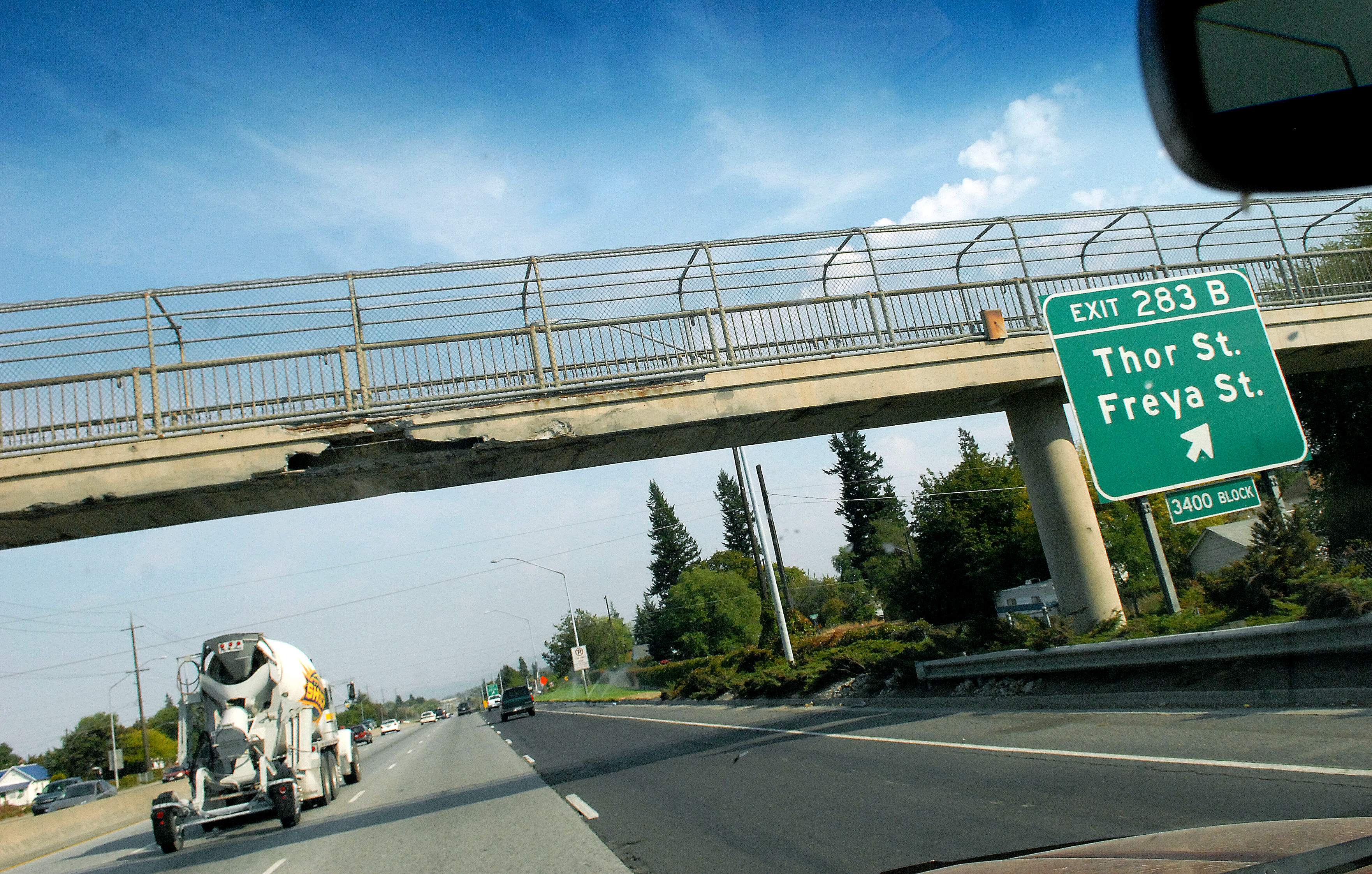
The Washington State Department of Transportation plans to bring the North Spokane Corridor through the north side of East Central and link it to I-90 around Altamont Street by 2029.
That doesn’t exactly please Wilkerson.
“I’m sorry,” she said about those plans, “WSDOT did kind of screw East Central.”
But she’s glad the department has begun pursuing a plan that would mitigate some of the disconnection its new highway project will exacerbate.
With the backing of the city of Spokane and support from Wilkerson, the East Central neighborhood council and others, WSDOT recently submitted a grant that would allocate $1.3 million to “look at the potential of a land bridge across I-90,” according to Char Kay, the department’s regional planning and strategic community partnerships director.
The goal, Kay said, would be “to restore areas that have been bifurcated by the interstate infrastructure” near Liberty Park.
The nearest approximation of such a structure in Spokane is the piece of Riverfront Park that spans Washington Street.
The idea for such a structure began to emerge in 2016, when the U.S. Department of Transportation held a workshop in the neighborhood.
There, “participants focused on the partially built U.S. 395 North Spokane Corridor (NSC) and the aging Interstate 90, examining strategies to build connectivity, restore opportunity, and mitigate impacts of the planned U.S. 395/I-90 interchange,” according to documents prepared by the city of Spokane to support WSDOT’s grant application.
That federal Rebuilding American Infrastructure with Sustainability and Equity, or RAISE, grant would pay for WSDOT to enlist consultants to design “two or three concepts” and to conduct extensive community outreach, according to Shauna Harshman, the City Council’s manager of neighborhood connectivity initiatives.
WSDOT should know whether it gets the grant by Nov. 22, but Harshman said a few general parameters already guide the vision for what the land bridge would be.
“I think all of the ideas that we are exploring are based on multimodal (transit) and green space,” she said.
The result, she said, would be a park-like span that would provide improved connections for the Ben Burr Trail, as well as a more pleasant crossing for residents.
“Our goal is to help mitigate the impacts (of highway projects) to low-income and minority populations, because this would reconnect people to services, businesses and jobs,” Harshman said. “That’s the big thing. There’s such a disconnect between where people live and how they access services, business and jobs. … The active transportation network in East Central isn’t as good as it could be, so there are some gaps in the network in East Central both in terms of bikes and pedestrians. So we hope this can close some of those gaps at the same time it’s reconnecting the neighborhood.”
Another aim, she said, would be to restore some of what was lost when I-90 took 26 of Liberty Park’s original 28 acres, as well as its status as a public space that rivaled Manito Park.
Harshman acknowledged the bridge’s size won’t be “even close” to big enough to restore the entire amount of parkland that was lost. She also said area planners have discussed a more expansive cover like a cap or a lid for the interstate.
Those bigger solutions are “incredibly expensive,” and the land bridge would meet some of the same goals without “the sticker shock of one of these caps or lids,” Harshman said.
As for what the cost would be, that won’t be known until the planning process is complete.
While the grant offers the most obvious path to that point, Harshman said it’s not the only option.
“Even if we don’t receive this award for planning, the NSC placemaking efforts are still going to be looking at good ways to make crossings across I-90,” Harshman said. “So that’s still on the table, even without this.”
Randy McGlenn, chairman of the neighborhood council, said the plans for the new freeway present “a number of challenges,” but the land bridge would be a welcome mechanism for mitigating some of the disconnect.
“This grant in particular for this land bridge would go a long way to improving accessibility for active transportation and pedestrian access north and south of the freeway,” McGlenn said. “And it would definitely be a modern and much more appreciated addition to green space and placemaking for the neighborhood in terms of this land bridge, versus the existing pedestrian bridges, which I don’t think most people would care to use, especially in their present state.”
While Wilkerson strongly supports the grant too, she is already looking to push for more improvements to make up for the disproportionate impact of the highway system on East Central.
“What I would like to see is another green overpass down at the other end of the East Central neighborhood,” she said. “What are we doing for the neighborhood down by Fred Meyer’s, Sheridan Elementary? So that would be my hope that we could then duplicate it at both ends of the community.”
Work to watch for
Work on school safety projects continues this week at the following locations:
- Weile Avenue/Court is open with lane restrictions from Pittsburg to Crestline Street.
- Rowan Avenue is open with lane restrictions from Howard to Stevens Street.
- Whitehouse Street is open with lane restrictions from Queen to Rowan Avenue.
- 23rd Avenue will have lane restrictions near Garfield Street starting Tuesday.
Work on the South Gorge Trail in Peaceful Valley continues on Clarke Avenue between Maple and Spruce streets, and on Wilson Avenue between Ash and Maple streets.
Starting Tuesday, crews will be working at the northwest corner of Wellesley Avenue and Maple Street on a project to improve traffic flow. The westbound left turn lane will be lengthened by approximately one block via island modifications between Maple Street and Walnut Street. Drivers should expect periodic lane closures.
Maple Street Bridge deck inspection is underway, and drivers should expect temporary lane closures.
Crews will start a grind and overlay project on Indian Trail Road between Barnes Road and Ridgecrest Drive on Tuesday.