This column reflects the opinion of the writer. Learn about the differences between a news story and an opinion column.
Getting There: City aims to add new kinds of protected bike lanes along Illinois Avenue

Are telescopes too much to ask?
Probably.
The city of Spokane has decided to remake East Illinois Avenue as it passes through the Logan and Bemiss neighborhoods, from Cincinnati Street to Market Street.
While the project will likely include mechanisms for protecting bicyclists that have never before been implemented in Spokane as well as improve a badly deteriorated road, some of the neighbors who showed up at a virtual meeting last week to discuss potential designs expressed concern that the proposals might not go far enough, including a suggestion for tools to peer up into the night sky.
A number of them said they had been dreaming about the opportunity to rehab the street for years.
And it’s easy to see why.
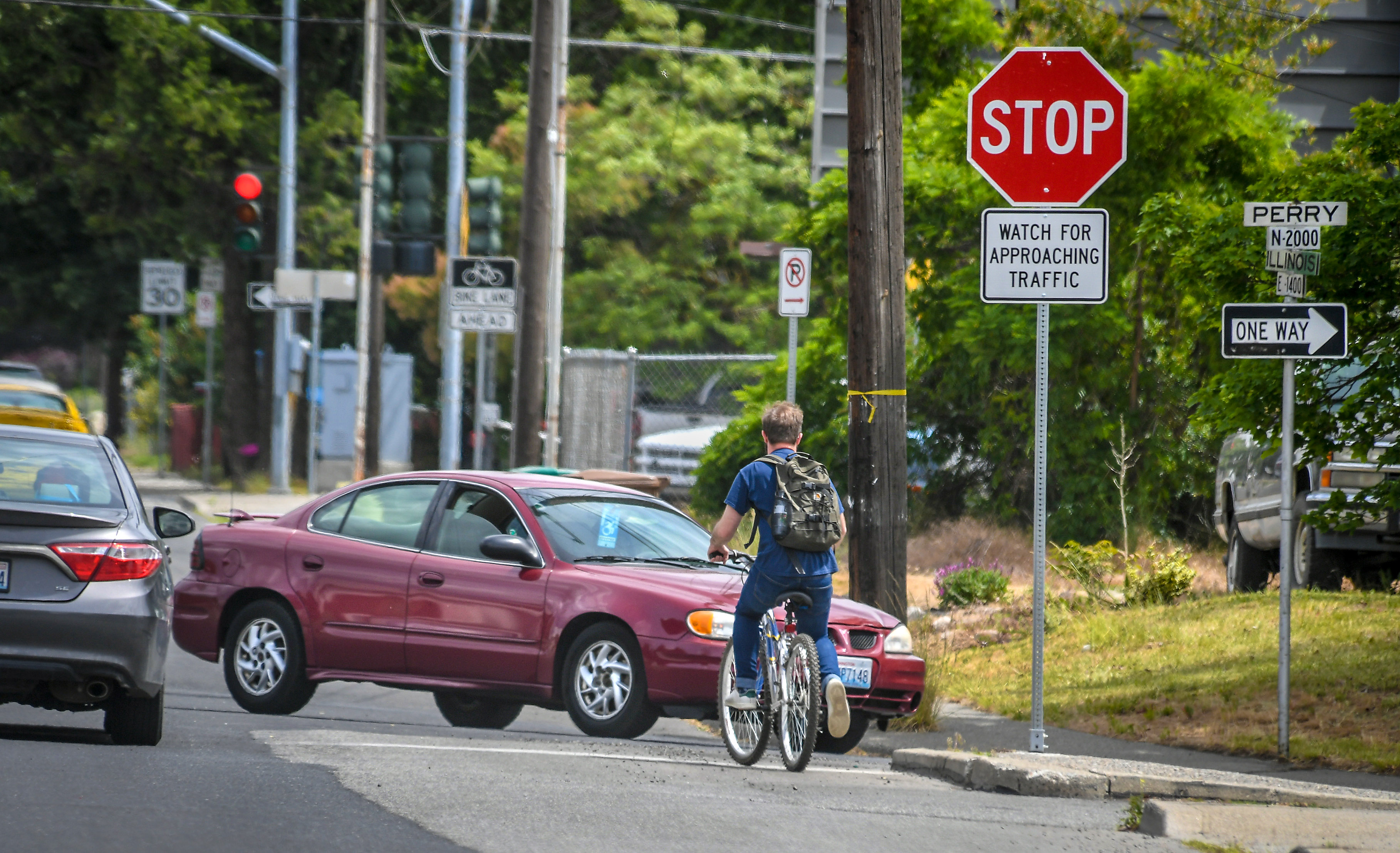
Along its eastern stretch, Illinois is as wide and fast as it is pothole-marred and washboard-like. And while the street runs along a bluff with views of the Spokane River and distant mountains, it’s hard to enjoy them due to the cars parked along the south side of the street, the traffic whizzing (and bumping) past, the weeds that are taller than the guardrails, and the lack of sidewalks, benches or other pedestrian-friendly amenities.
The City Council acknowledged the need to do something last year, when it passed a resolution calling for protected bike lanes to be added to the street. Around the same, the city’s public works department made plans to remake the pavement between Perry and Market.
“With these two things happening, we said, ‘There’s potential for some low-hanging fruit,’ ” Kevin Picanco, a senior engineer with the city, told attendees of Thursday’s meeting.
In order to pluck it, Picanco said, the city decided to pause the grind-and-overlay project while it came up with a plan.
Or, rather, a series of possible plans along distinct three sections.
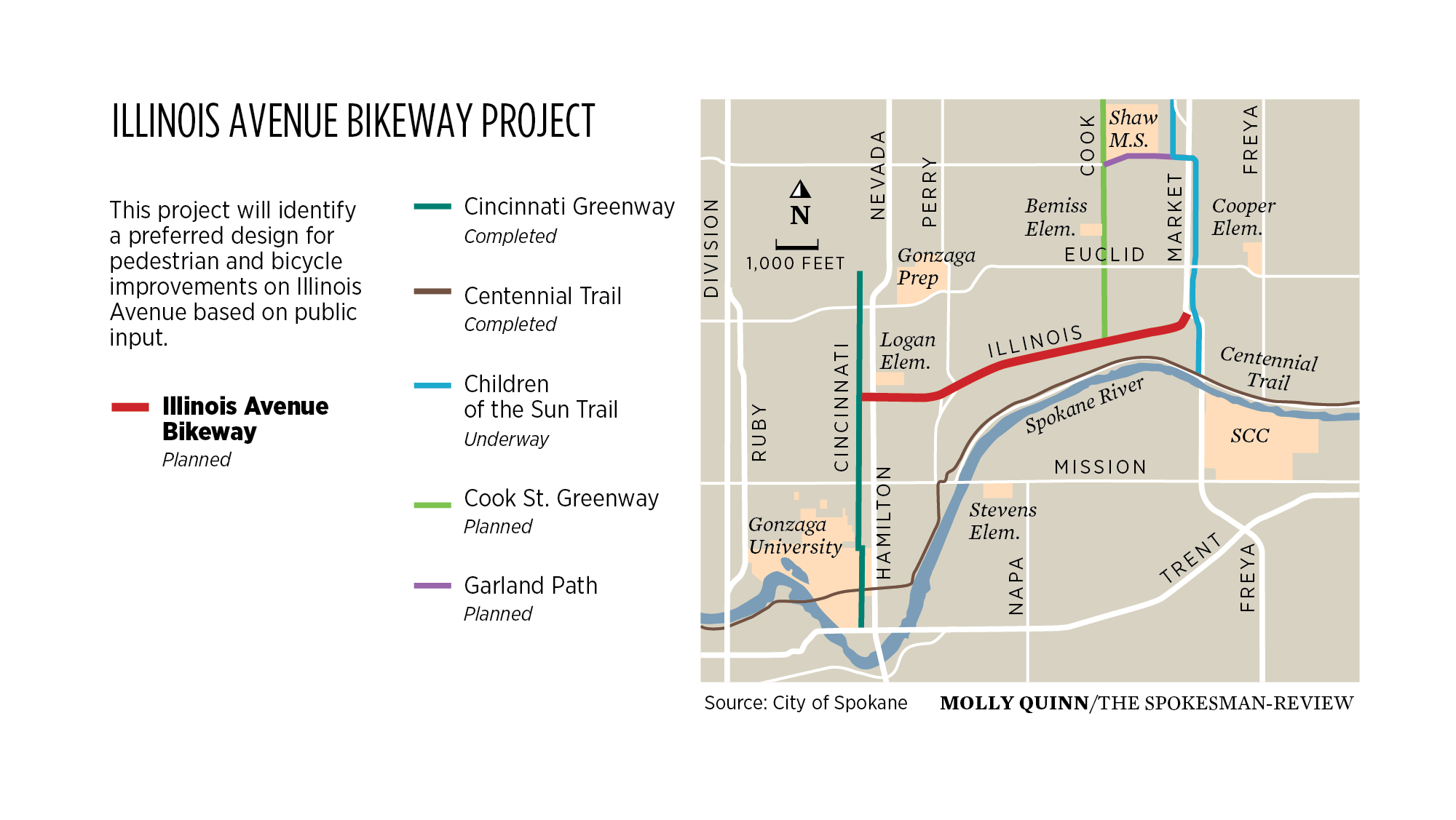
The westernmost piece starts one block west of Hamilton Street, at Cincinnati, where the city recently completed a greenway project that intends to prioritize bikes and pedestrians over cars. It ends at Perry.
The city has drafted three options for that section. In one, a protected bike lane would replace parking on one side of the street. In the others, both bike lanes would be added adjacent to the sidewalk.
The changes may also involve narrowing the roadway, Picanco said.
Picanco said a narrower road may also be a slightly slower road for cars. While that’s not the main objective of the project, according to Picanco, he called it a potential “benefit.”
The central section of the project area is the brief but complicated stretch between Perry Street and Perry Place, which act as a couplet that moves traffic north and south on one-way roads.
The current configuration involves two lanes of traffic on westbound Illinois, both of which have the option to turn south on Perry Street without stopping. To make that possible, eastbound traffic on Illinois stops before crossing Perry Street.
The city has drafted two potential ways to deal with this section, both of which include buffered bike lanes on either side of Illinois. The main difference is that one option would eliminate one of the two eastbound lanes and bump out the southside sidewalk to take advantage of the extra room.
The eastern section of the project, from Perry to Market, is where the roadway is the widest and the potential for change is greatest. The city presented six options on Thursday, all of which entailed removing parking on the bluff side, but the central question is whether to add a 12-foot shared use path or cycle track on the bluff-side of the street.
It seems support for such an addition exists. The cycle-track proposal won a snap poll taken during the meeting, though participation wasn’t exactly overwhelming. (The winner got three votes.)
Despite the plans to remake the street and boost access to the bluff, not everyone thought the city was being sufficiently ambitious in planning for a street that does currently have bike lanes in each direction and that has the potential to be a community gathering point.
Donna Fagan, chair of the Bemiss Neighborhood Council, wished for water and bike-repair stations and for places where people could stop, rest and look out over the bluff, including at night, with telescopes aimed toward the south.
“That’s the dream,” she said.
While Picanco said the current planning process “doesn’t preclude other ideas that are maybe more long-term ideas because of cost or because of difficulty of implementation,” he also suggested the neighborhood would be wise to embrace the “lower-cost ideas” presented in order to take advantage of the impending grind and overlay.
Amber Waldref, a former city councilwoman who lives in the neighborhood, was among those who argued planners ought to seek more funding, perhaps from the city’s traffic calming program, and push for more improvements.
She noted the neighborhood had been pursuing improvement for “three or four years” and should take full advantage of it finally being realized.
“When you have an opportunity to touch a street and do it right, I think we should work really hard to find those traffic calming dollars and put it in the way the neighborhood wants it,” Waldref said.
The city plans to refine its design options, solicit more public feedback and select a plan late this year. Meanwhile, more information about the existing proposals, as well as a survey, is available online at my.spokanecity.org/projects/illinois-avenue-bikeway-design-options.
Whatever the city does on Illinois, the options presented so far would provide an important link connecting northeast Spokane bicyclists and pedestrians to the coming Children of the Sun Trail to the east and to the Cincinnati Greenway to the west.
It could also introduce Spokane to some forms of protected bike lanes that haven’t yet reached the city and that are key to making people feel safe and comfortable enough not to drive.
Colin Quinn-Hurst, a city planner, pointed to a few places around town where bike lanes are separated or raised, such as on the South Gorge Trail in the Peaceful Valley, along the under-construction section of the Centennial Trail along Sunset Boulevard and on Main Avenue downtown.
But Illinois Avenue could be the first site in the city for a number of other options for separating bikes from motor vehicle traffic, such as raised curbside bike lanes adjacent to the sidewalk, separated two-way cycle tracks or parking-protected curbside bike lanes.
Illinois, though, may not be the last place where the city incorporates these designs – or the first.
Quinn-Hurst said the city is currently working to incorporate similar bike infrastructure along Riverside Avenue and on a route that will connect the North Bank area of Riverfront Park to the Gonzaga campus via Boone Avenue, Atlantic Avenue and a portion of Sharp Avenue.
Ray-Freya alternatives
The city continues to sort through its options for improving traffic flow around Ferris High School, and planners are open to your input.
A public meeting on Wednesday at 5 p.m. will offer residents an opportunity to learn more and offer their thoughts about how to improve 37th Avenue where it intersects with Ray and Freya streets and about what to do with land that was once slated for a new road to be called the Ray-Freya Crossover.
The city is now considering a 12-foot shared use path instead of the road, as we reported in February, but you’ll have to tune in on Wednesday for more: my.spokanecity.org/projects/ray-freya-alternatives-analysis.
STA gets funding from federal package
The Spokane Transit Authority will receive $5.8 million of American Rescue Plan funding for the City Line bus rapid transit project, the U.S. Department of Transportation announced Friday.
But because the City Line project was already fully funded, the new money will allow STA to move $5.8 million in local funds to other projects, according to Brandon Rapez-Betty, STA’s director of communications and customer service. And there are no shortage of them.
STA is currently moving forward with plans for a second bus rapid transit line along Division Street, as well as other service expansions and infrastructure improvements.
Airway Heights downtown test
Airway Heights is planning to modify U.S. Highway 2 and King Street as it seeks a city center for the sprawling West Plains settlement.
To help it decide how to transform King into a pedestrian-friendly corridor, the city is conducting a demonstration project this month that will allow it to test out changes to changes to streets and intersections before making permanent improvements.
The temporary improvements, which include enhanced pedestrian infrastructure, bump outs, street art, protective landscaping, and a community area, are on view between Highway 2 and 6th Avenue.
For more information, visit storymaps.arcgis.com/stories/451a7f541ebd4f47bb40693f67d06139.
Work to watch for
The Hatch Street Bridge will be inspected on Friday. Drivers should expect lane closures and flaggers on-site from 8:30 a.m. to 4 p.m.
Wall Street between Main and Riverside avenues will be completely closed Monday through Wednesday for excavation.
The two westbound lanes of Riverside Avenue between Division and Bernard streets will be closed through Friday for excavation.
The intersection of Ray Street and 18th Avenue will be flagged in all directions as needed from Wednesday through June 30 for utility work.
Spokane Transit Authority work will lead to the following:
- One eastbound lane of Mission Avenue is closed between Dakota and Hamilton Street until mid-June.
- One westbound lane of Mission Avenue is closed between Hamilton and Dakota Street until mid-June.
- Access to Cincinnati Street is closed at Mission Avenue until mid-June.
Washington State Department of Transportation maintenance crews will begin making repairs to the pavement on Paradise Street/S.R. 270 between S.R. 27/Grand Avenue and Kamiaken Street in Pullman on Monday. Crews will fully close eastbound travel only on Paradise Street on Monday from 7 a.m. to 5 p.m. Single-lane closures of Paradise Street will continue through Thursday, each day from 7 a.m. to 5 p.m.