Fires grow in Washington, Idaho with heat advisory in place

As the Chuweah Fire in Okanogan County torched more than 30,000 acres Friday, other fires in Eastern Washington and North Idaho also tested fire departments.
Despite the fires, Spokane’s air quality Saturday remained in the healthy range, according to the Spokane Regional Clean Air Agency. It was expected to dip into the moderately healthy range later in the day.
Light wind and hot temperatures expected for Sunday and Monday could bring moderate to more severe air quality conditions, according to the agency.
The National Weather Service in Spokane also said a change in wind patterns and possibility of dry lightning could lead to fire weather patterns Tuesday and Wednesday.
Low relative humidity is also expected next week, the weather service said.
Here are updates on other fires nearby:
Red Apple Fire
A fire burning near Wenatchee in Chelan County held steady at 11,111 acres Saturday, with containment at 51%.
The Chelan County Emergency Management said on its Facebook page evacuation orders for Warner and Swakane canyons were reduced to Level 2, which means residents should be ready to leave. Nahahum Canyon is under Level 1 evacuation orders as of Saturday, a downgrade from the Level 2 orders issued earlier.
Other evacuations remained, with a Level 3 “go now” order for the unpaved portion of Burch Mountain Road.
Level 1 orders, meaning residents need to be aware of danger, included the east side of Burch Mountain Road and Ohme Garden Road, U.S. Route 97A from Ohme Garden Road to Bob’s Apple Barrel, everything north of American Fruit Road, and everything north of Easy Street from U.S. Highway 2 to Burch Mountain Road.
Evacuation orders were lifted for all areas south of American Fruit Road and Easy Street from Burch Mountain Road to Highway 2, according to the Chelan County Emergency Management.
Lick Creek
A lightning-caused fire previously known as the Dry Gulch Fire southwest of Asotin grew to 68,153 acres and was 30% contained Saturday.
Level 2 evacuation orders remained in place for residents on Lickfork Road, Smoothing Iron Road and Harlow Ridge Road in north Asotin County, according to a map on the Lick Creek Fire Facebook page. Toward the south, Level 2 evacuations were set for Hansen Ridge Road, Cougar Creek Road, Grouse Flat Road and Joe Mace Road. Residents living east of South Fork Road and west of Meyers Ridge Road were given a Level 1 evacuation order.
In Garfield County, Level 2 evacuation orders were set for residents living north of the Clearwater Lookout until Bosley Grade Road, and everyone west of the Mountain Road until the Asotin County line, according to the Lick Creek Fire map on Facebook.Officials closed all Forest Service lands, roads and trails within the Pomeroy Ranger District of the Umatilla National Forest, according to a release from the Umatilla National Forest. State and county roads remained open Saturday.
Summit Trail
A blaze 17 miles west of Inchelium erupted after a lightning storm. The fire grew to 1,457 acres and was 0% contained, according to a release from the Confederated Tribes of the Colville Reservation.Closures include the Colville Reservation and all forest roads. State and paved county roads remained open as of Saturday afternoon.
A California Incident Management Team 10 took command of the fire Saturday.
Trestle Creek Complex
A fire about 7 miles north of Hope, Idaho, held steady at 286 acres and was 31% contained Saturday morning, according to the Idaho National Panhandle Forest.
The complex is made of six different fires, with the sixth as the largest and least contained as of Saturday morning: Trestle 1, 90% contained; Trestle 2, 100% contained; Trestle 3, 100% contained; Trestle 5, 100% contained; Trestle 6, 0% contained.
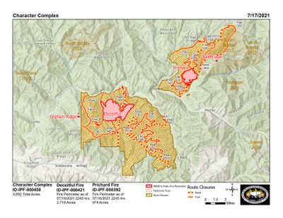
Character Complex
In Idaho, two fires near the Coeur d’Alene River grew to 3,315 acres and was 0% contained Saturday afternoon.
The Deceitful Fire 3 miles north of Kellogg, Idaho, was the largest at over 2,500 acres. A Level 1 evacuation order was set for residents around Prichard and Murray, according to the Idaho Panhandle National Forests.
Idaho Panhandle National Forests lands around the fire areas prompted road, trail and area closures Saturday.
The Shoshone County Sheriff’s Office closed Eagle Creek Road, Montgomery Ridge Road and Bobtail Road at Prichard Creek. The Prichard Fire in the Eagle Creek Drainage was around 800 acres as of Saturday afternoon.
Cougar Rock Complex
Fires about 30 miles north of Orofino, Idaho, grew to 3,835 acres and were 15% contained Saturday afternoon.
Closures include the Granddad Bridge on the Dworshak Reservoir and at Captain’s Cabin near Elk River. These areas remained open for industrial traffic Saturday.
Leland Complex
Crews made progress on the Sand Mountain, Pine Creek and Bonami fires Saturday, the Idaho Department of Lands said.
The Sand Mountain Fire, the largest of the three, was 1,320 acres and 5% contained. The Pine Creek fire held at 542 acres and was 100% contained. The Bonami Fire was at 6 acres and 80% contained.
Officials kept the campgrounds and trails near Sand Mountain closed Saturday, which included the Laird Park and Potlatch Delta leases.
The Nez-Perce Clearwater National Forest rangers also closed the entire upper area of the Palouse Ranger District to the public, according to its website.