This column reflects the opinion of the writer. Learn about the differences between a news story and an opinion column.
Getting There: Ray-Freya crossover back in play, with pedestrian path replacing street

The question of how to better move traffic up and down the South Hill between the Lincoln Heights and Southgate neighborhoods and around Ferris High School has confounded city planners for more than half a century.
For much of that time, the proposed solution was a street that would pass through Ferris’ property.
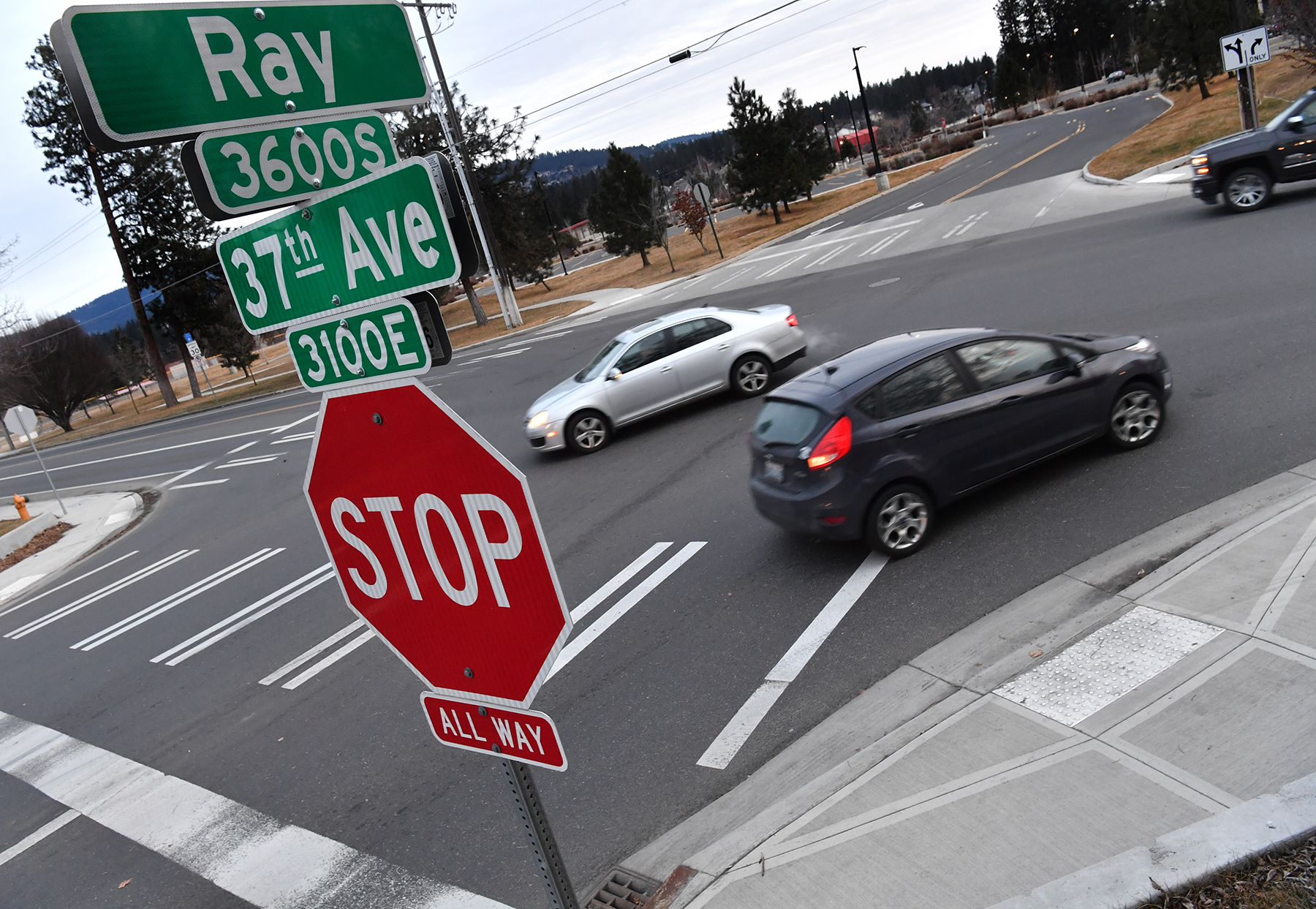
Now the city has turned its focus to a new bicycle and pedestrian path, plus some alterations to the intersections of Ray and Freya streets with 37th Avenue.
The new plan both builds on, and departs from, those of the past.
A proposal to improve traffic flow around Ferris first entered the city street plan in 1966, when officials envisioned an extension of Ray Street that would go straight south from its current dead end at 37th Avenue. There, planners also proposed the so-called Ray-Freya Crossover, funneling traffic between the two north-south arterials.
But resistance from the school district led City Council to revise its conception of the crossover. In 1986, council approved a resolution for a new street connecting Ray to Freya on a supposedly less intrusive diagonal alignment through the school property.
Over the next few years, the city worked to make that new street a reality, even acquiring homes at the northeast corner of 37th and Ray to provide right-of-way for the northernmost point of the future crossover. And when plans were drawn up to redesign Ferris in the 2000s, the school property was designed to leave a path for the route of that planned diagonal connection.
Just as construction on the school began in 2011, though, the city started to back off its commitment to the street due to an outcry from neighbors. Then in 2017, the city officially stripped the crossover from its Comprehensive Plan, which guides growth.
That appeared to be the nail in the crossover’s coffin, even as the need it for it kept growing.
Without the Ray-Freya improvements, much of the traffic instead simply migrated a few blocks to the west, to Regal Street, which has become increasingly built up and congested.
Now, with Regal so overused that its traffic woes have stalled plans for much-needed new housing, the crossover is back in play, in a radically different form.
The city still owns the right-of-way through Ferris’ property and at the corner of 37th and Ray, and it has been working with a consultant since 2019 to come up with a new solution for traffic woes in the corridor.
The result is a $40,000 study that has come up with two slightly different alternatives with some fundamental elements in common.
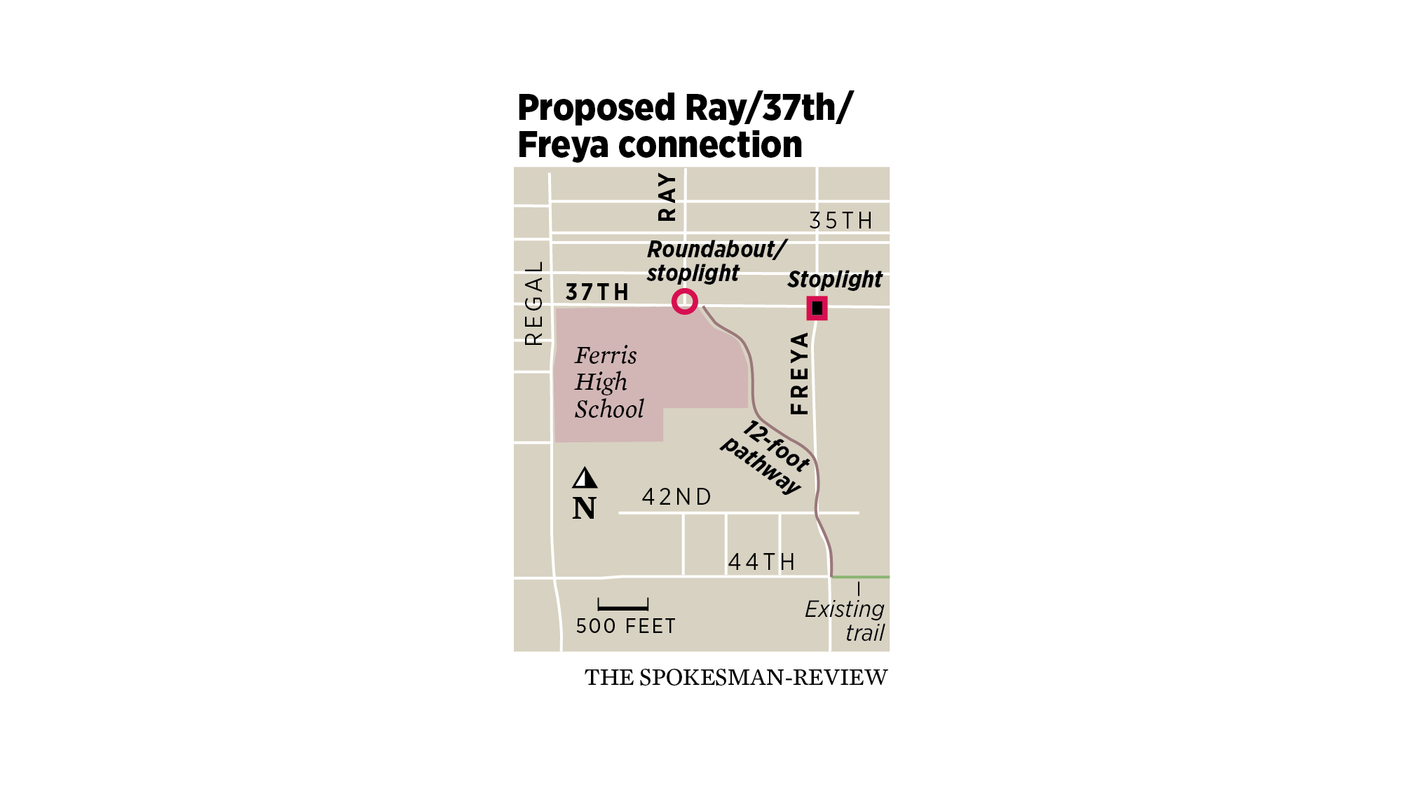
For one thing, both options entail using the city’s diagonal right-of-way through the Ferris property as a 12-foot shared-use path, instead of as a street for motorized vehicles. That path would hook up to a brief section of an existing path on 44th Avenue and could even tie into a long-term effort to extend the Benn Burr Trail to the Moran Prairie, according to Inga Note, a senior traffic planning engineer for the city of Spokane.
For another, the two alternatives each seek to improve the flow of traffic through the Ray and Freya intersections with 37th Avenue, though in slightly different ways.
In one option, traffic signals would be added at both intersections and would include extra turn lanes to “prioritize the flow of traffic from Ray Street to Freya Street,” according to a city website about the alternatives. The Freya signal also would be programmed to help the flow of evening commuter traffic toward the south, the site says.
In the other option, a roundabout would be constructed at Ray and a traffic light would be installed at Freya.
The roundabout, which would expand the intersection’s footprint, would include a westbound-to-northbound bypass lane to prioritize the morning traffic flow down the South Hill.
To get feedback about the alternatives, the city has posted information as well as a survey online, available by clicking on the Ray-Freya Alternatives Analysis link at my.spokanecity.org/projects. Planners also will host a meeting at 5:30 p.m. Wednesday for citizens to learn more and provide feedback. Information about how to participate will be posted to the same site beforehand.
But while the website and the meeting deal with the two latest proposals, Note said it’s possible the city will go in a somewhat different direction – or even back the way it came.
“We do have the ability to look at another alternative or two,” she said, if good ones come up in the public-feedback process. She added that she and her colleagues “want to take the time to evaluate what might be another good solution.”
She even signaled that the idea of a street through the Ferris property could be revived.
That possibility is totally off the table, she said, “assuming we don’t get overwhelming support to go back to the crossover option.”
Closures of Harvard Road overpass, I-90
coming to Liberty Lake
Interstate 90 and Harvard Road over Interstate 90 in Liberty Lake will see full and partial closures over the next two months as part of a Washington State Department of Transportation plan to widen the overpass.
Daytime lane closures to restripe the Harvard Road overpass will occur Tuesday and Wednesday from 9 a.m. to 3:30 p.m.
A single-lane closure of I-90 will occur March 16, from 11 p.m. to 5 a.m. before full closures occur March 17-19, during the same time period.
A detour will be provided for both the eastbound and westbound I-90 closures. Drivers traveling eastbound I-90 will take the Harvard Road-Liberty Lake interchange and head east on Appleway Avenue to the State Line interchange to rejoin I-90.
During the westbound closure, crews will exit I-90 at the Harvard Road-Liberty Lake interchange, drive through the roundabout, and rejoin I-90 using the on-ramp.
Work to watch for
Both curbside lanes of Five Mile Road between Elgin and Ash streets will be closed and traffic flagged through Friday for Avista work.
The intersection of Hatch Road and 54th Avenue will be flagged in all directions from Monday through March 15 for Avista work.
The intersection of Crestline Street and 48th Avenue will be flagged in all directions from Monday through March 15 for Avista work.