WSDOT touted new placemaking engagement process for NSC, but Minnehaha residents say their input ‘didn’t matter’
Shannon Benn went door to door, soliciting input from her neighbors in Minnehaha.
So did Barbara Stout-Henggeler, her co-chair on the neighborhood council.
Isaiah Bryant took paid time off from his job to attend meetings.
A new freeway was coming to Minnehaha, after decades of planning, and the Washington State Department of Transportation wanted their input.
But the department wasn’t just using the usual public-outreach tools as it moved toward construction of the southern half of the North Spokane Corridor.
It was 2017, and WSDOT was launching a form of public engagement it had never tried before that put “community–based participation at its center,” according to WSDOT materials.
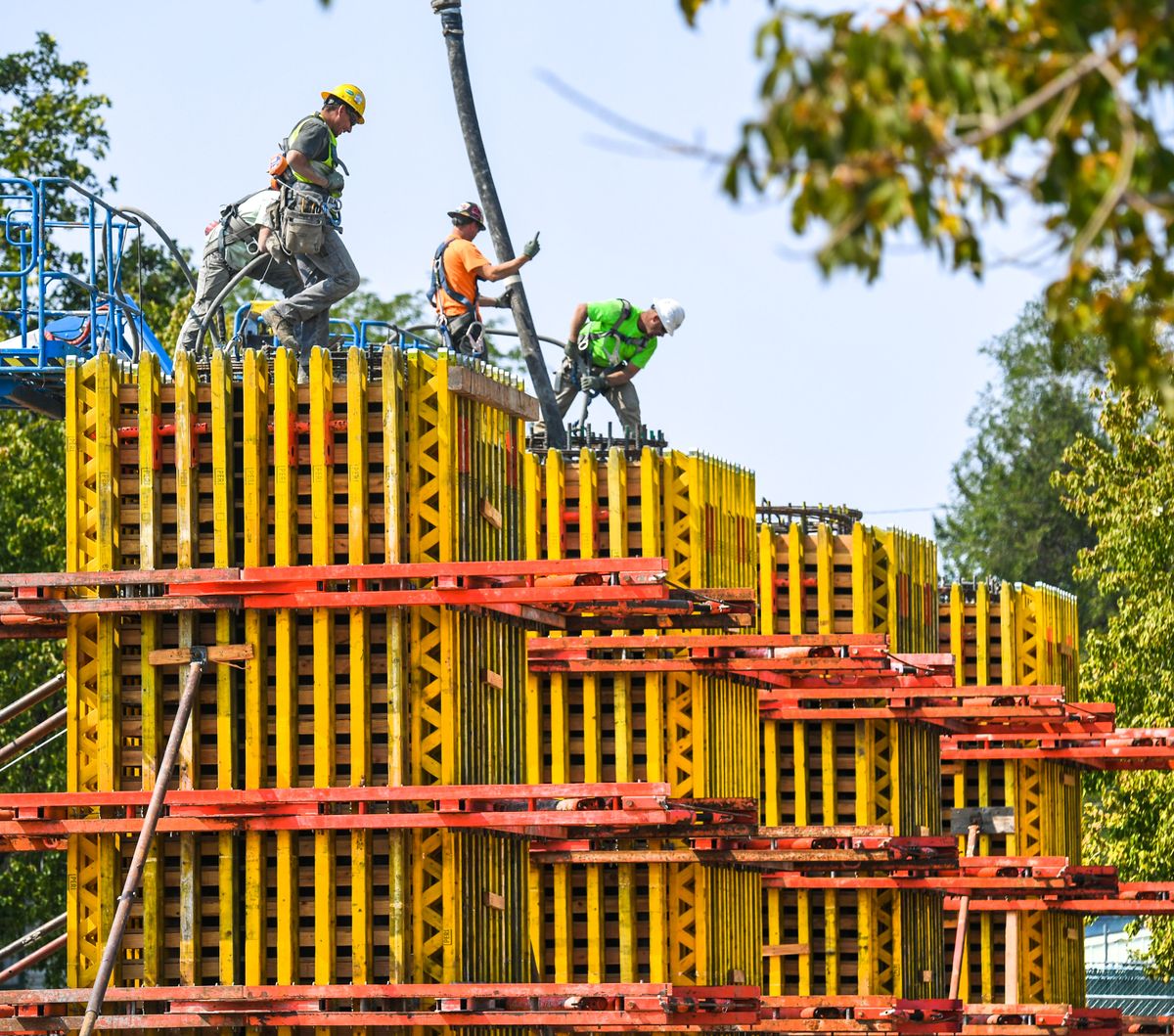
The process was called “placemaking,” and Benn, Stout-Henggeler and Bryant took seriously the opportunity to provide input about what would happen when the $1.5 billion, four-lane highway landed in the northeast neighborhood that stretches from the Spokane River to Garnet Avenue and from Market Street to Havana Street.
But while they came up with a long list of ideas for how to lessen the new highway’s impact as it passed through Minnehaha, they say WSDOT ignored essentially all of them.
“They had the agenda,” Stout-Henggeler said. “But they just had to talk to us, just to hear us, and they were done. Because they had their agenda, what they were gonna do. It didn’t matter what we said.”
Benn agreed.
“I don’t think we won – if you could call it on a win-or-lose basis – I don’t think we won on a single offer, idea or anything that we put out there,” Benn said. “They just said, ‘This is what we’re doing.’ ”
What WSDOT has done is closed many of the streets that lead in and out of Minnehaha to make way for the new highway.
Bridgeport, Fairview, Cleveland, Grace, Marietta and Jackson streets were all permanently closed in 2019.
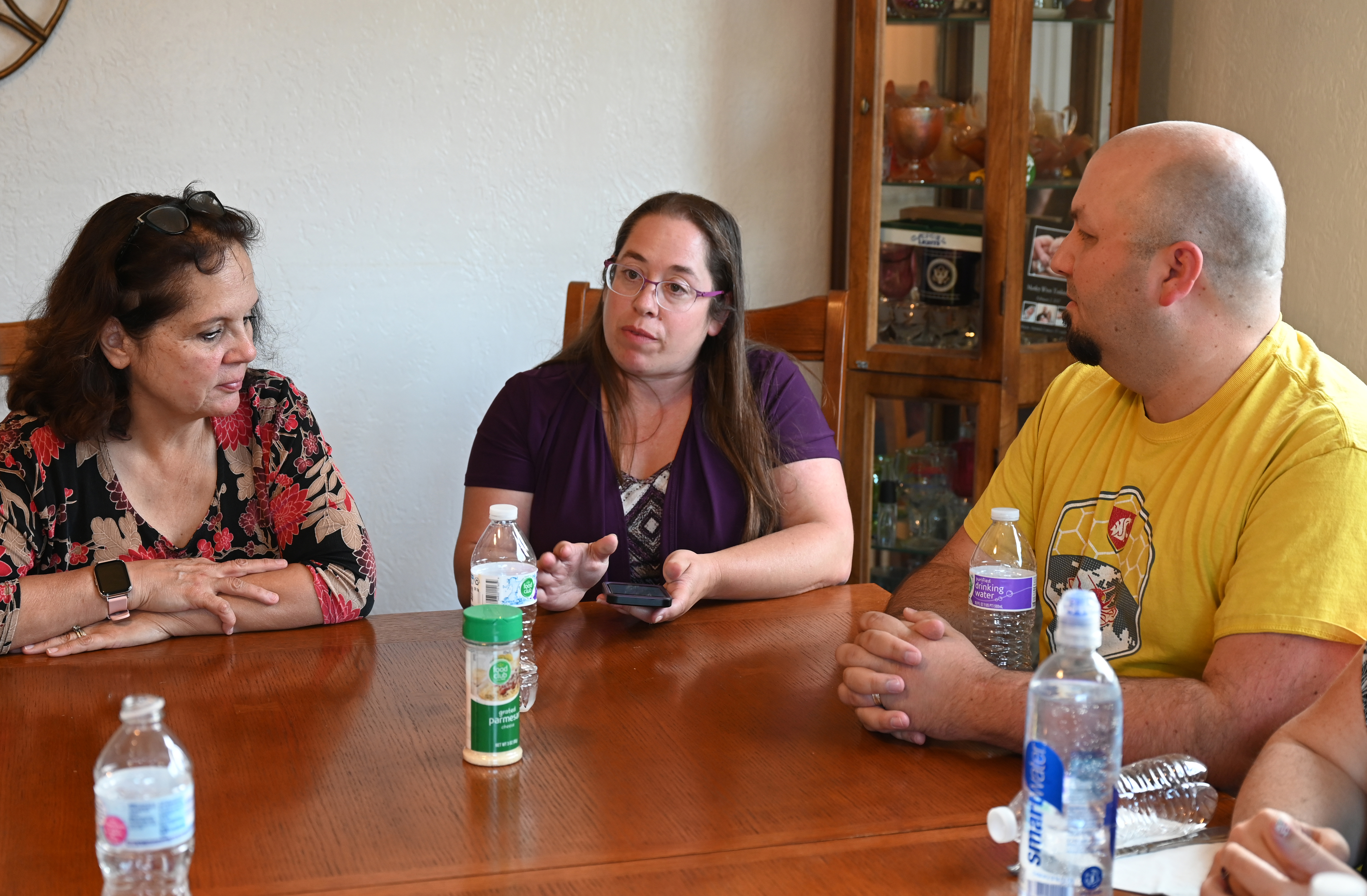
That has left Minnehaha residents with few good options to get in and out, according to Benn, Stout-Henggeler, Bryant, his wife Megan and Liz Vandenberg, who gathered around a dining room table recently to talk .
The main artery in and out of Minnehaha is Euclid Avenue.
And while the corridor is slated to pass over Euclid on a bridge, allowing the street to remain open in the long term, a BNSF rail line was relocated at street grade, right alongside the path of the new highway, creating an intermittent barrier to traffic.
Other than Euclid, there’s no direct way to exit the neighborhood to the south.
Residents heading east or west can merge onto Upriver Drive on their way out of the neighborhood’s south end, but the traffic they have to merge into isn’t controlled by a traffic signal or a stop sign.
There’s Carlisle Avenue, which will remain open between Euclid and Upriver, but it only allows vehicles to enter from the south or to leave to the north onto Greene Street.
And since 2019, when WSDOT closed Wellesley for major reconstruction, the nearest way to leave north after Euclid has been to drive two miles up Freya Street to Francis Avenue. While that will change in 2022, when Wellesley Avenue, located one mile north of Euclid, reopens after major reconstruction, WSDOT will close Euclid for periods of up to two weeks at a time to allow for construction of the highway overpass.
WSDOT expects all work in Minnehaha to be complete by late 2023, but the highway isn’t scheduled to be finished until 2029.

The neighborhood residents interviewed for this story said they believe a finished freeway will be a good thing, overall, because it will channel through-traffic off their streets. In the meantime, though, they are worried about congestion, safety and access.
“It will be nice when it’s done,” Benn said. “But it would have been nicer if they would have taken to heart what we were trying to tell them three or four years ago, in saying, ‘Look, this is going to cause a lot of heartache for a lot of people.’ ”
‘An open-ended process’
That is not how the placemaking process is supposed to end, according to Elena Madison.
“If the neighborhood doesn’t get what it wants out of the process, then clearly the process has failed,” Madison said.
And she should know.
Madison is the director of projects at the Project for Public Spaces, the nonprofit that invented the placemaking concept in 1995 to invert the usual infrastructure-planning process by beginning with community engagement, instead of soliciting stakeholder approval after a project was already in the works.
While WSDOT has touted its use of the placemaking process and reproduced materials from the Project for Public Spaces as part of the highway community-engagement efforts, Madison said the department’s approach appears to have deviated from the spirit of placemaking.
“I see the principles of placemaking are quoted on the (North Spokane Corridor) website,” Madison said. “But what does it mean and how are these principles being applied? I think at the end of the day, the proof is in the pudding.”
Madison was reluctant to evaluate WSDOT’s use of the placemaking process, but she said the NSC project appeared to deviate from the outset.
“The whole point is, I can’t see a genuine process in a situation where you have decisions that have already been made,” Madison said. “The whole point of the placemaking process is that it’s an open-ended process. The plans have to be able to change as the process evolves.”
‘A rich and deep process’
Officials from WSDOT, though, argue that the placemaking process they employed was open-ended and responsive from the very beginning – and that it remains so.
They also argue that criticisms of its use of the process miss a central fact: Many of the decisions, including those about the freeway’s path and which streets its construction would close, were made long before the placemaking process began in 2017 and therefore weren’t within the bounds of discussion.

Mike Gribner, administrator of WSDOT’s Eastern Region, said the decision to use the placemaking process began with a conversation between him, Char Kay, WSDOT’s region planning and strategic community partnerships director, and state Secretary of Transportation Roger Millar in 2016, standing on the grade of the section of the new highway that was already complete.
They discussed the fact, Gribner said, that they were “coming into a new area that had a lot of neighborhood interest. What was our opportunity? What was the agency’s opportunity to help folks realize the things they were trying to get done in these neighborhoods while the facility was being constructed there? How do we leverage that opportunity?”
As the conversation between Gribner and Kay continued, they enlisted the help of Kerry Brooks and the Eastern Washington University urban and regional planning department where he works.
But though they ultimately landed on the placemaking process, Gibner said they weren’t aiming to reproduce a pre-existing method.
“Our goal, quite frankly, was not to completely copy a process that somebody else uses, although we certainly like the ideas of placemaking and a lot of the stuff that was very insightful and inspirational,” he said. “We needed to create something that fit within the constraints that we were going to have on a project that was already half-built, that had been committed to through legislation. So we weren’t going to come into this with a brand-new open slate. We had to fit this idea – the agency’s new view of this – within the current constraints that the project was under.”
Those constraints were major. Among them was the fact that the course of the interstate had already been determined through an environmental impact statement completed in 1997, modified in 2001 and put through a conventional public engagement process.
“We were very transparent about what we could and couldn’t do,” Gribner said.
What they could do was engage the community to help design the space around the coming highway as well as the second-half of the course and design of the Children of the Sun Trail that will run alongside the corridor.
What they couldn’t do, Gribner and his colleagues said, is make major changes to how the project was engineered.
With those limitations in mind, Kay said they allowed the community leeway to decide what it wanted through targeted engagement, online media and four-hour workshops known as “charrettes” that included morning and afternoon activities, according to a draft summary of the process.
WSDOT and a team from EWU hosted three initial neighborhood charrettes, one in Hillyard, one for Minnehaha and one for both Bemiss and Whitman. They also set up “listening posts” at community events, attended neighborhood council meetings, and hosted follow-up meetings between 2017 and 2019.
During the morning activity, attendees were given “Special Place Evaluation worksheets,” worked “collaboratively to rate 20 place qualities for each Special Place” and were then “asked to specify if the Special Place should be protected, connected, enhanced, and/or remade,” according to a summary document.
During the afternoon activity, participants did a “sticker mapping” activity where they were “offered color-coded, numbered solutions describing specific interventions which might help create place in relation to the corridor or through other means. Six primary categories were presented: Streetscape, Edges, Trail, Crossings, Skyway and Stormwater Facilities,” according to the draft charrette summary. Also available were “Make Your Own Idea” stickers.
Organizers of the placemaking process also hosted a charrette devoted to the Children of the Sun Trail. Hosted on a single day, people were invited to attend from the Bemiss, Whitman, Minnehaha, Hillyard, East Central and Chief Garry Park neighborhoods.
Those who came were allowed to develop the guiding principles for the trail’s design and to develop conceptual trail design alternatives.
Bob Hilmes, project engineer for the corridor office, said the input from those charrettes has led engineers to create “enhanced plazas” at multiple locations along the trail north of the river and to begin charting the trail’s course south from its current terminus at Columbia Avenue.
Among the changes made “through the public engagement process,” Hilmes said, were the addition of pedestrian crossings over Wellesley and Euclid avenues as well as the addition of a pedestrian-only bridge spanning Upriver Drive and the Spokane River. The project will also include a pedestrian bridge over the freeway at Garland Avenue.
But the Minnehaha Neighborhood Council representatives said they asked for a long list of other changes, such as raising the rail line above Euclid, creating over- or underpasses at some of the closed streets, adding capacity for cars to use the pedestrian bridge planned at Garland, and building a bridge at Havana Street to give them a connection to the south.
Hilmes acknowledged those were “things that they brought to us.” But, he said, “they were things that were not feasible.”
While those concerns focused on adding access, Brooks, from EWU, emphasized that the decision about the street closures were “a given for the placemaking process.”
Brooks said it would be wrong to think that the placemaking process “ignored those requests” about access “because that was pre-placemaking process.”
“I just think that we should not say that, well, placemaking would be invalidated because the community couldn’t get roads across a gigantic berm that’s being produced in those locations in Minnehaha,” Brooks said. “That’s not a realistic expectation in any case, in my opinion.”
“You go from what you have and you work with the community to figure out what a desired feature would be,” Brooks continued. “I don’t think it’s a fair assessment to be going down the road of saying, ‘People didn’t have input on keeping all these roads open as part of placemaking.’ That was never on the table. That was one of the givens of the project. Every single project has givens.”
As for what was on the table, Brooks said it was evaluated through a “rich and deep process. And from my perspective, we’ve helped facilitate the articulation of the community’s voice.”
Kay also emphasized that the process was not meant to “determine the location of the freeway, whether it existed or not, how it was going to built.” Rather, it was to consider what to do with “the spaces in and around the Children of the Sun Trail,” as well as the trail’s location, and with “the development of space and place in the interface of the highway with the adjacent communities,” Kay said.
Among the considerations that were part of the placemaking process, though, was the look and feel of the interstate walls.
Hilmes said the process helped WSDOT come up with “architectural textures that are cast into the concrete components of the bridges and the walls … that reflect those themes and preferences by the community.”
‘The process itself’
Those who engaged with the placemaking process in Minnehaha acknowledge their input about the design along the sign of the freeway was accepted.
They chose horses to match the mascot of the neighborhood elementary school, the Cooper Stallions.
But Madison, from the Project for Public Spaces, said that isn’t the kind of community involvement that amounts to placemaking.
“I don’t want to be criticizing other people’s work without being aware of the details,” she said. “But, yes, a situation where all the major decisions have been made, homes have been demolished and people are being displaced and the placemaking process comes to add murals to the overpass, that is not placemaking.”
Placemaking, she said, is a process that typically begins by setting a goal, such as improving mobility, and then engages a community to come up with their preferred method of achieving it.
Along the way, Madison said, a “successful placemaking process could also be about the process itself, about empowering neighbors and residents and other stakeholders in the community.”
“It cannot only be about meeting some higher goals at the expense of the community,” Madison said. “So if the neighborhood doesn’t get what it wants out of the process, then clearly the process has failed.”
“Tacking on public meetings when decisions have been made,” she added, “is not placemaking and is not genuine.”
‘Meet us halfway’
Alex Mann believes that’s exactly what happened.
He had an inside view of the placemaking process.
For the first half of 2018, he served as a researcher and project manager for the WSDOT North Spokane Corridor and Children of the Sun Trail placemaking charrette process while employed in EWU’s urban and regional planning department.
His role, he said, was to “design events or workshops where people in the community could express its placemaking vision” and to then “interpret the results of that and to present the information” to his colleagues.
By the time he became involved in the North Spokane Corridor, Mann points out, it had been underway for decades and had already been halfway built, with its path to completion already charted.
As he “came to understand placemaking” while working on the freeway project, Mann said he realized that the way he and his colleagues were using it was “completely antithetical” to its intended approach.
“Placemaking is fundamentally a grassroots, bottom-up approach,” he said. “It specifically argues for non-top-down approaches and not to be implemented as a way of justifying infrastructure projects.”
When he expressed concerns about WSDOT using it for exactly that purpose, Mann said he continually “ran up against” the “notion that, ‘Well, we can’t be perfect all the time.’ ”
Mann said the problem was more fundamental.
“It’s not about being perfect,” Mann said. “It’s a matter of placating people and misrepresenting what you’re doing.”
Brooks, from EWU, strongly rejected that characterization, saying, “I would not stay on this project if I thought they (WSDOT) were talking through their hats.”
Mann argued that WSDOT was putting a freeway through a series of neighborhoods without offering residents meaningful opportunities to decide how it would be built, much less whether it would be built.
The use of placemaking language and materials, he said, “doesn’t change the fact that the fundamental import or the fundamental result of the project will be the exacerbated disconnect of the neighborhoods.”
He said the “community did not get to say which streets will be closed.” Rather, that was an “engineering reality,” Mann said.
“They got to pick and choose what they wanted to make placemaking for and to say, ‘No, no, no, this stuff is off-limits. You can’t say these streets will not be closed.’ … That is, right off the bat, antithetical to the people-first, community-desire-first foundation of placemaking.”
He said the apparently positive elements of the project, like the Children of the Sun Trail, don’t make up for the negative effects that will come in the form of disconnected streets, increased traffic and increased carbon emissions.
“They’ll be able to point to any number of things and say, ‘We’re doing it better than we used to do it. We’re making this project more multimodal, more pedestrian-friendly,’” Mann said. “But the reality is it will be a net detriment.”
Ultimately, Mann said those issues led him to quit his position.
“I came to realize that, fundamentally, even if there were some projects created in the community that would be a net good, the reality would be that the entirety of the project would be a negative,” he said. “Once the highway is built, you can’t unbuild it. It’s a wall in the community with a few gates. It’s a polluting wall and a traffic-boosting wall. … And you don’t have to build a highway to build a north-south bike trail. So you can’t say it’s a testament to multimodal transportation.”
The members of the Minnehaha Neighborhood Council don’t view the freeway the same way as Mann does.
Benn said she believes “it’s going to be a good thing” and that “the route they chose probably was the most logical.”
Her neighbors who gathered to discuss the placemaking process expressed agreement.
When complete, they envision the freeway as a mechanism that takes traffic off their neighborhood’s streets and improve residents’ ability to move swiftly north and south through the city.
Hilmes said “modeling shows that there will be a reduction” in traffic on neighborhood streets.
“But modeling also shows that there will be areas growing,” Hilmes added. “So while modeling shows it could be a reduction based off what it could be, it may be as much as it is today for certain locations.”
Even the Minnehaha neighbors’ general support for the project doesn’t assuage their frustrations about the process.
“It seemed, if they were going to do as much as they were to our neighborhood as they were, they would take a little bit more of our input and meet us halfway,” Benn said.
‘What are the opportunities?’
While Gribner acknowledged it “is very difficult for an agency like DOT to strike 100% success on what everybody wants out of a process,” he not only strenuously defended WSDOT’s use of placemaking for the highway but also said it will transform how the agency conducts public outreach going forward.
“I think engagement really did change, and will change, how this agency will do public engagement in the future,” Gribner said.
He and his colleagues emphasized that the highway’s placemaking process is not over. They plan to continue to use the same methods to gather input from communities south of the river that will help determine the final route of the Children of the Sun Trail, with the next meeting likely to be held in October.
There is also work to do on maintaining, programming and continuing to improve the spaces that are constructed along the corridor, Kay said.
Gribner said WSDOT is in the “process of transforming public policy” after its experience with placemaking along the NSC.
“We’re leaving in place a project that’s going to be here for a long, long time,” Gribner said. “We want them to feel good about it, we want them to own part of it.
“We think we took some pretty good strides in that direction in this process.”
And he said the direction the agency is heading will take it somewhere new.
“This isn’t the last time we’ll do a public engagement process,” he said. “But it is the last time we’ll do it the old way, because we’ve learned a lot here and we like what we did, we like how this came out.”
As it moves forward with construction of a new highway through Spokane, WSDOT is also looking to heal the effects of the last major freeway project to create division in the city’s neighborhoods.
Kay said the agency is working with the city of Spokane to pursue a statewide active transportation grant that would “look at the potential of a land bridge across I-90” in East Central to “restore the area around Liberty Park.”
While that project is still in a “highly exploratory” phase, Kay said its evidence that the agency is willing to go to great lengths to “restore areas that have been bifurcated by the interstate infrastructure.”
“We listen and we keep in our minds, ‘What are the opportunities?’ ” Kay said. “And we try to connect them.”
Benn said it’s just those issues of bifurcation and connection that concern her about the NSC’s effect in Minnehaha.
“If you take a look at East Central,” Benn said, “you have a completely wiped out and barren area, (with) trees only and golden grass that runs alongside of the freeway, and we don’t want that to happen over here.”