This column reflects the opinion of the writer. Learn about the differences between a news story and an opinion column.
Getting There: City goes back to drawing board to design Fish Lake Trail connection
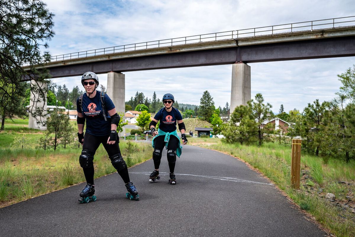
Liz Morley, in front, and Michele Faus set off as they skate the Fish Lake Trail on May 12, 2020. The city is hatching plans to connect the Centennial Trail to the Fish Lake Trail. (COLIN MULVANY)

It cost $202,236 for the city to produce the Fish Lake Trail Connection Study, but what that money didn’t buy was a decision.
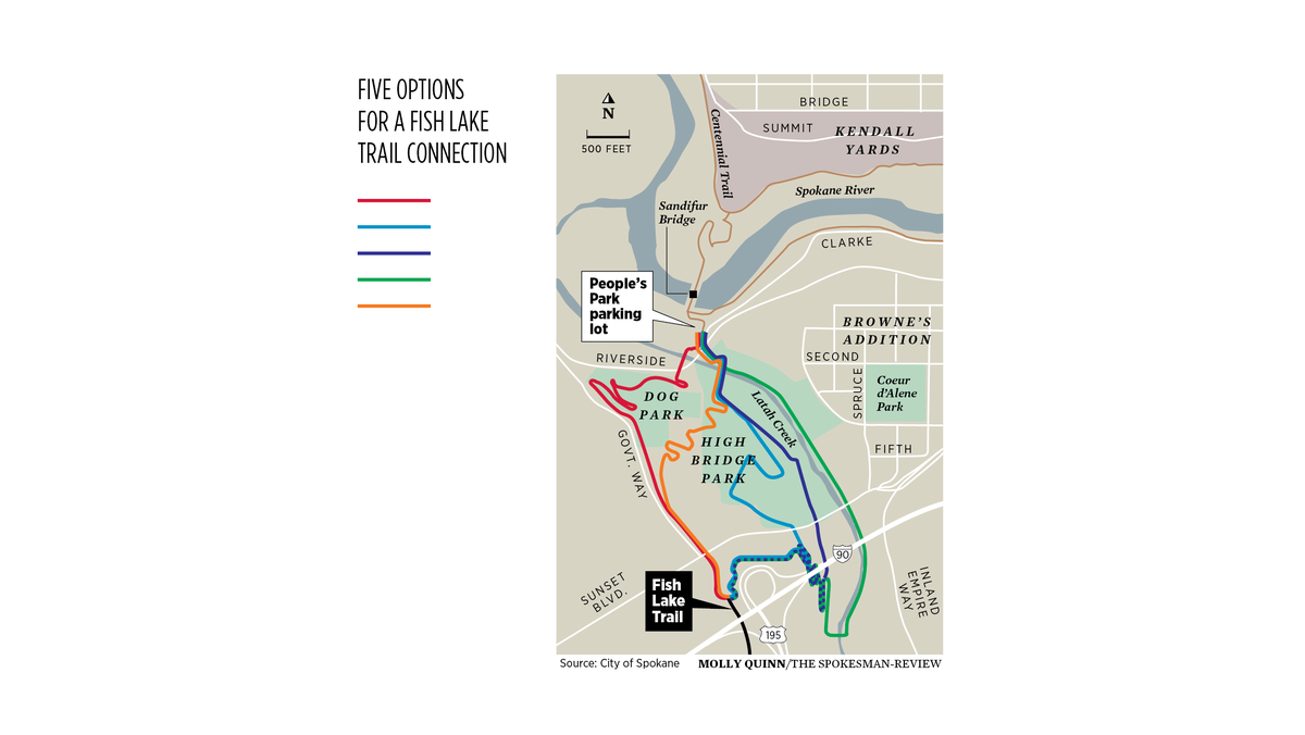
After 33½ pages of analysis of four alternatives for connecting the trail’s current terminus on South Lindeke, near the Interstate 90 and U.S. Highway 195 interchange, to both the Centennial Trail and developing South Gorge Trail in Peaceful Valley’s People’s Park, a reader of the study comes to a subhead that promises a “Recommended Alternative.”
What follows, though, is a blank space.
Notably, the user of the existing Fish Lake Trail comes to a similarly disappointing conclusion on the far end of the trail, which ends at a chain-link fence, instead of at the promised Fish Lake.
While it remains unclear when or how the trail will ever make it to its namesake, the Spokane City Council allocated an additional $82,355 to study a fifth option for tying the Centennial, South Gorge and Fish Lake trails together, one they hope will allow the study process to come to an end and trail construction to begin.
Inga Note, a senior traffic-planning engineer, has already sketched out that additional route by melding elements of the two most popular of the original four options.
The most popular of those options, among the 1,320 people who provided input, was known as the blue route.
That route would have avoided major streets, heading east from the current Fish Lake trailhead and passing beneath the iconic Sunset Bridge and into High Bridge Park, where it would follow alongside Latah Creek before crossing the stream at Riverside Avenue and entering People’s Park.
A majority – 793 people, to be exact – preferred that route, attracted to the possibility of a trail that would take them away from streets, into nature and along the creek.
“A lot of people like the blue route because it was going through the woods and was more natural and felt more in character with the rest of the trail that way,” Note said.
When asked their “highest priority as a trail user” in the city’s survey, two-thirds of respondents picked “park-like environment along the trail.”
But a significant share of people were also worried that the seclusion afforded by that option would have its drawbacks, Note said.
“They were concerned about safety and illegal activity in High Bridge Park and homeless people,” she said.
A summary of the city’s survey data supports that assessment, noting that the most frequent comments included things like “Not comfortable riding the blue route due to isolated setting and homeless camps” and “Safety for solo females should be a high priority.”
Another source of objection was the potential impact to High Bridge Park’s disc golf course.
“There’s a pretty vocal disc golf community,” Note said.
Hence, apparently, the fact that another frequent comment was that the blue route “would require changes to the popular disc golf course and could put bikers and walkers at risk of being hit by errant discs,” according to the survey summary.
Note said the blue route also posed some engineering challenges, such as the presence of erodible soils under the Sunset Bridge, that would “be tricky and expensive” to deal with.
At an estimated cost of $11.8 million, the blue route would be more than $4 million pricier than the red route, which is expected to take $7.5 million to construct in its simplest form.
Those savings come at the cost, however, of the natural feeling and separation from cars that the blue route would have offered.
After leaving the current Fish Lake trailhead and crossing Sunset Boulevard, the red route would closely follow Government Way, cut through the northwest corner of the SpokAnimal Dog Park, cross Riverside Avenue and cross Latah Creek via a newly built bridge to reach People’s Park.
The red route got 417 votes in the survey but, as Note said, “it puts (the trail) next to the road and a lot of people don’t like that.”
Not only is it unpleasant to bike beside traffic, it’s also dangerous. More dangerous, it seems safe to say, than biking among homeless people. Consider, for example, that eight deaths and 27 serious injuries resulted from crashes involving cyclists and pedestrians in the city of Spokane last year, according to WSDOT data.
The city, however, decided not to engage in that comparison.
“I didn’t really see that we could pick one and move forward and get consensus from all the users,” Note said. “So I started thinking.”
She also started walking, in order to take another look at the landscape and the options.
When she came across an area southeast of the dog park where a path has already been made through the woods for utility lines, Note saw an opportunity for compromise.
Instead of red or blue, she would meld elements of both, taking the path across Sunset and along Government Way for a shorter stretch, before dropping down to a seemingly less scary section of High Bridge Park. The result was what’s now the orange route on a revised city map.
“I came up with it, and then took a few of the members of our technical committee to look at it and ran it through city staff and through (City) Council, and they were positive,” Note said. “They want to come up with something that everyone’s going to like.”
Dan Schaffer, a longtime advocate for the Fish Lake Trail, said he thinks concerns about the blue route were “overblown” and based on the false “image of the homeless as predators.”
But he also acknowledges the need to move forward.
“Any trail solution is going to be a compromise one way or another,” Schaffer said. “I think what we have to do is what is acceptable to people and what can the city afford to do.”
With new funds in hand, Note said the city will finish analyzing the orange route before going back to the public to see whether it’s acceptable to a sufficiently large share of those who respond.
If such a consensus is reached, she expects more public outreach ahead of a final decision in the spring, when the city would aim to start seeking funding for the project.
And that is ultimately what Schaffer, for one, wants.
“If it gets done, it’s better than not doing it at all,” he said. The orange route is “not a bad solution,” he added. “It wouldn’t be my No. 1 . But it’s better than the red route … so I can live with it.”
Meanwhile, Schaffer is continuing his longtime advocacy for such a solution at the trail’s southern terminus, where the city and county have yet to finalize a plan for crossing the BNSF railroad tracks that currently prevent the trail from reaching Fish Lake and Cheney.
Schaffer said that crossing was studied about a decade ago, and a solution involving a pair of bridges was designed at that time.
But since that option hasn’t materialized, guess what will need to be done before any progress can be made?A new study.
Westbound I-90 ramp in Liberty Lake closing
Drivers headed south on Harvard Road in Liberty Lake will have to drive west to Barker Road to hop on I-90 for almost the next two weeks.
That ramp for southbound traffic onto the westbound interstate closed Sunday at 7 p.m. and will remain closed through 4 a.m. on Aug. 20 to allow crews working for the Washington State Department of Transportation to finish paving the extension of the ramp and realign it with I-90.
During the closure, the northbound Harvard Road loop on-ramp to westbound I-90 will remain open.
Crews initially planned to close Harvard Road over I-90 beginning Monday for work to widen the bridge over I-90. But extreme temperatures led the contractor to change its plans.
The Harvard Road closure over I-90 is now tentatively scheduled to begin when the ramp work is done Aug. 20.
Work to watch for
There’s a whole lot of chip-seal work going on.
In the city, the work will be underway at the following locations:
- Monday, crews will be working on Post Street between Cleveland and Maxwell avenues and on Wellesley Avenue between Milton and Ash streets.
- Tuesday, crews will be working at Freya Street between Wellesley Avenue and Upriver Drive.
- On Wednesday, crews will be working at Southeast Boulevard between Perry Street and 29th Avenue.
- On Thursday, crews will be working at Freya Street between 37th Avenue and Palouse Highway.
- Crews will also be working this week in the vicinity of Finch Arboretum and in the Indian Trail neighborhood at various times.
In the county, chip-seal work will be underway on Thierman Road from Weile Avenue to Valley Springs Road; on Valley Springs from Thierman to Spokane city limits; on Jackson Road from Morris Road to Valley Chapel Road; on Morris from Jackson to state Route 27; and on Prairie View Road from Fairfield city limits (Jackson Road) to Waverly city limits (Fourth Avenue).
WSDOT crews closed the loop on-ramp to eastbound I-90 at the Geiger Boulevard interchange last week. Drivers will use the roundabout south of I-90 to access the directional on-ramp to eastbound I-90 during the four-week closure.