Fires prompt Colville National Forest to close trails, campgrounds, roads in Tonasket, Three Rivers ranger districts

The Colville National Forest closed a number of campgrounds, trails and roads in the Tonasket and Three Rivers districts on Monday.
“The vast majority of the forest is still open (with fire precaution restrictions),” said Charles Lassiter, a spokesman for the forest in an email. “The largest closures are around Bonaparte Lake (Spur and Walker Creek fires), Conconully (Cub Creek 2 and Muckamuck fires), and Boulder Creek Road (Bulldog Mountain fire). Those closure are on the Tonasket and Three Rivers Ranger districts, respectively.”
The closures are in response to the Spur Mountain and Bulldog Mountain fires, which were burning 2,000 and 1,800 acres, respectively as of Monday. The closures will remain in effect until Dec. 31, unless rescinded sooner.
Below is information on the closures provided by the Colville National Forest:
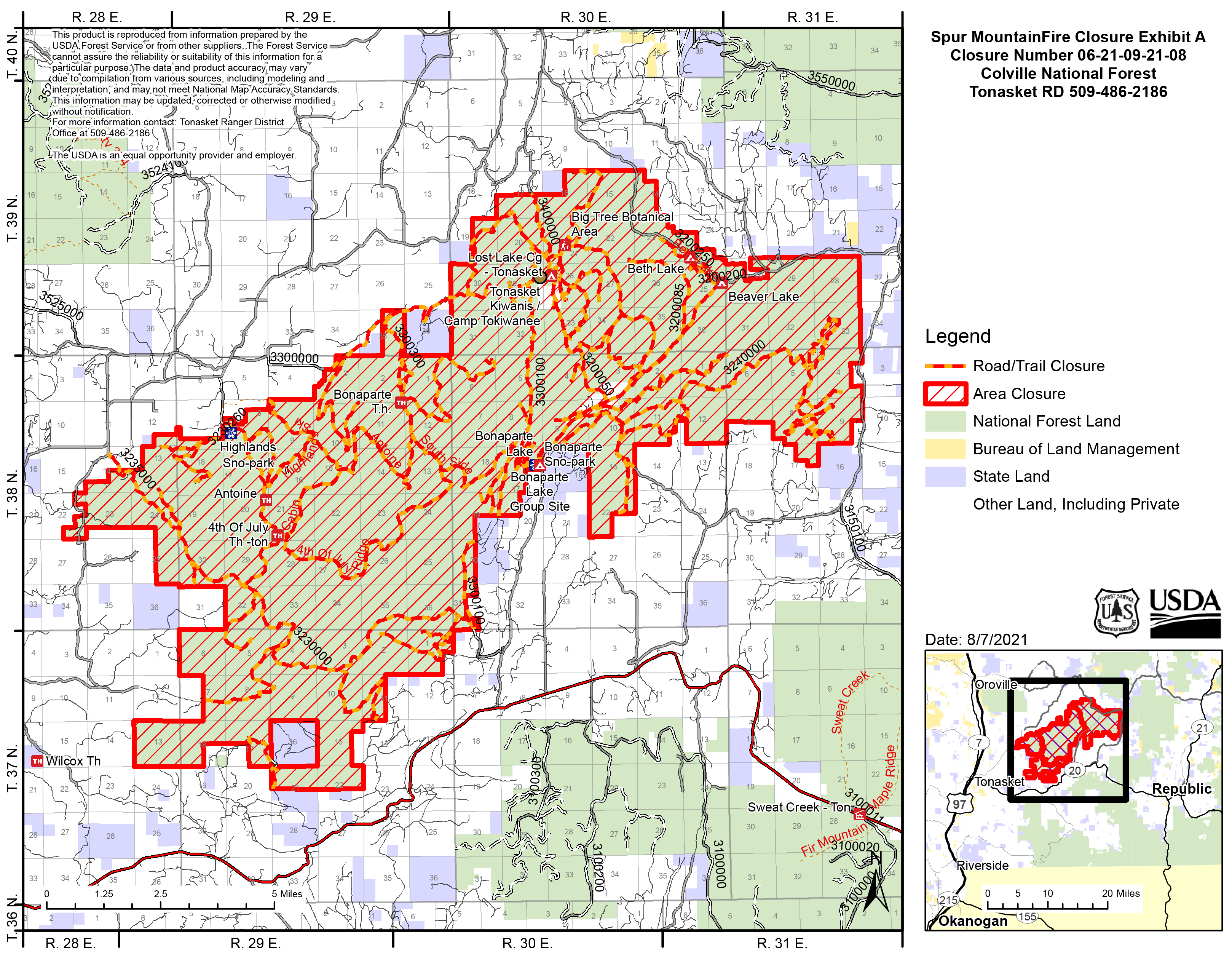
Tonasket Ranger District closures:Campgrounds:
- Lost Lake
- Bonaparte Lake
- Beth Lake
Trails:
- Trail 300 Highlands Ski Trail
- Trail 303 Cabin Trail
- Trail 304 Antoine
- Trail 306 Bonaparte Mountain
- Trail 306 South Site
- Trail 307 Fourth of July Ridge
- Trail 308 Southside
- Trail 309 Strawberry Mountain
- Trail 311 Big tree
- Trail 316 Beth lake
- Trail 322 Virginia Lilly
- Trail 383 Pipsissewa
Roads:
- 3200012 – Bonaparte CG
- 3200013 – Bonaparte CG
- 3200015 – Summer Home
- 3200020 – Boy Scout
- 3200030 – Rocky Reach
- 3200050 – Lost Lake
- 3200060
- 3200070 – Strawberry Flat
- 3200073
- 3200075 – Lost Lake CG
- 3200076 – Camp Ortoha
- 3200085 – Beaver Hump
- 3200200 – Beaver Lake CG
- 3200250 – Beth Lake CG
- 3220100 – Cayuse Horse Pasture
- 3220150 – Cayuse Horse Pasture
- 3230000 – Mill Creek
- 3230015
- 3230017
- 3230050 – S FK Siwash
- 3230090 – Fourth of July Ridge
- 3230260 – Highlands Trailhead
- 3230265
- 3235000 – Phoebe
- 3235032
- 3235035 – Quarry
- 3240000 – Cumberland
- 3240010 – Gravel Pit
- 3240020 – Meadow Creek
- 3240025 – Hayseed
- 3240130
- 3240177
- 3240180
- 3240185
- 3300000 – Box Canyon
- 3300015
- 3300040 – N. End
- 3300060 – W. Strawberry
- 3300064
- 3300100 – Spur Mt.
- 3300110
- 3300130
- 3300133
- 3300250
- 3300259
- 3300300
- 3300350
- 3400000 – Lake
- 3400020 – Pit Road
- 3200250A – Beth Lake CG
- 3200250-B -Beth Lake CG
- 3200250-C – Beth Lake
- 3200250D – Beth Lake
- PUD3200051
- 3230075
- 3240040 – Walker Cr.
- 3300120
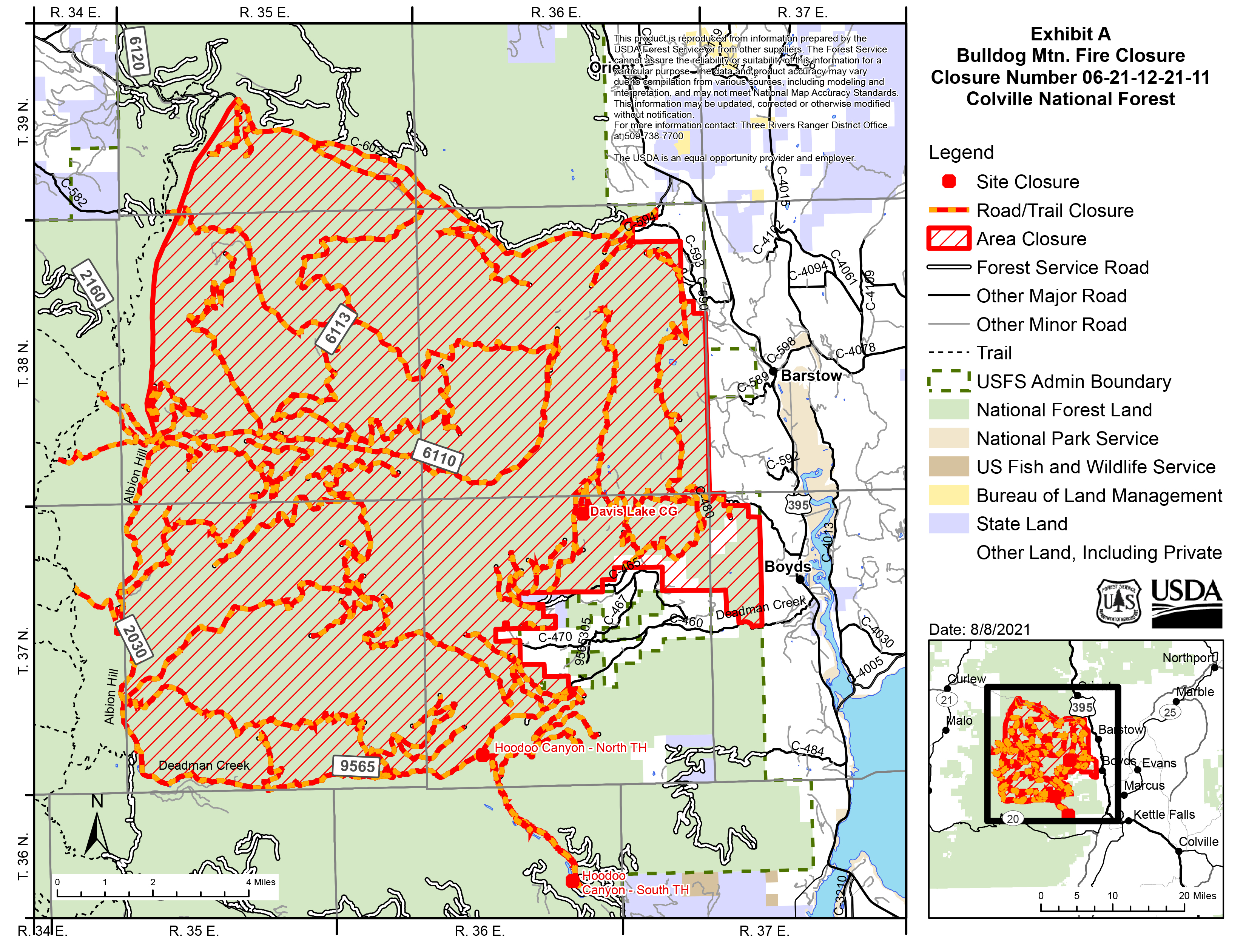
Three Rivers Ranger District closures:
Campground
- Davis Lake
Trails
- Trail 107 Thompson Ridge
- Trail 74 Taylor Ridge
- Trail 109 Twin Sisters
- Trail 98 King Mountain
- Trail 75 U.S. Mountain
- Trail 71 Stickpin
- Trail 30 Ryan Cabin
- Trail 75 Old Stage
- Trail 92 Davis Lake Shore
- Trail 17 Hoodoo Canyon
- Trail 94 Emerald Lake
Roads
- NFS Road 2030000 – Albion Hill (Closed from the junction with 9565000 – Deadman to 6110000 – South Boulder)
- NFS Road 2030600 – U.S. Mt. Jeep
- NFS Road 2030800
- NFS Road 2030900
- NFS Road 2030920
- NFS Road 2030921
- NFS Road 2030921A
- NFS Road 6100090 – Lower Cabin
- NFS Road 6100400
- NFS Road 6100420 – Upper Butte Creek
- NFS Road 6100421
- NFS Road 6110000 – South Boulder
- NFS Road 6110175
- NFS Road 6110178
- NFS Road 6110180
- NFS Road 6110400 – Laddie Creek Pit
- NFS Road 6110430 – Indian Creek
- NFS Road 6110500
- NFS Road 6110570
- NFS Road 6113000 – Bulldog Cabin
- NFS Road 6113325 – Echo Creek
- NFS Road 6113350
- NFS Road 9500702
- NFS Road 9500705
- NFS Road 9500710
- NFS Road 9500720
- NFS Road 9500730
- NFS Road 9500747
- NFS Road 9500755
- NFS Road 9500762
- NFS Road 9500860
- NFS Road 9500864
- NFS Road 9500870
- NFS Road 9500873
- NFS Road 9565000 – Deadman
- NFS Road 9565075
- NFS Road 9565077
- NFS Road 9565080 – Davis Lake Campground
- NFS Road 9565160 – East Jacknife
- NFS Road 9565162
- NFS Road 9565170
- NFS Road 9565180
- NFS Road 9565225
- NFS Road 9565260
- NFS Road 9565320 – North Deadman
- NFS Road 9565330
- NFS Road 9565450
- NFS Road 9565331
- NFS Road 9565360 – South Deadman Face
- NFS Road 9565361
- NFS Road 9565363 – Hoodoo A
- NFS Road 9565366 – Hoodoo Mt.
- NFS Road 9565520 – High Bridge Creek
- NFS Road 9565525
- NFS Road 9565535
- NFS Road 9565538
- NFS Road 9565570
- NFS Road 9565640
- NFS Road 9565800 – Alligator Ridge
- NFS Road 9565810
- NFS Road 9565820
- NFS Road 9565822 – Rock Pit
- NFS Road 9565824
- NFS Road 9565830
- NFS Road 9565840
- NFS Road 9565850
- NFS Road 9565860