This column reflects the opinion of the writer. Learn about the differences between a news story and an opinion column.
Getting There: New interchange opens at U.S. 95 and Highway 53 in North Idaho; West Plains Connection gets funding

On the one hand, it’s an innovation whose advantage is its simplicity.
On the other hand, it’s complicated enough that the Idaho Transportation Department has produced a computer-animated instructional video to teach drivers how it works.
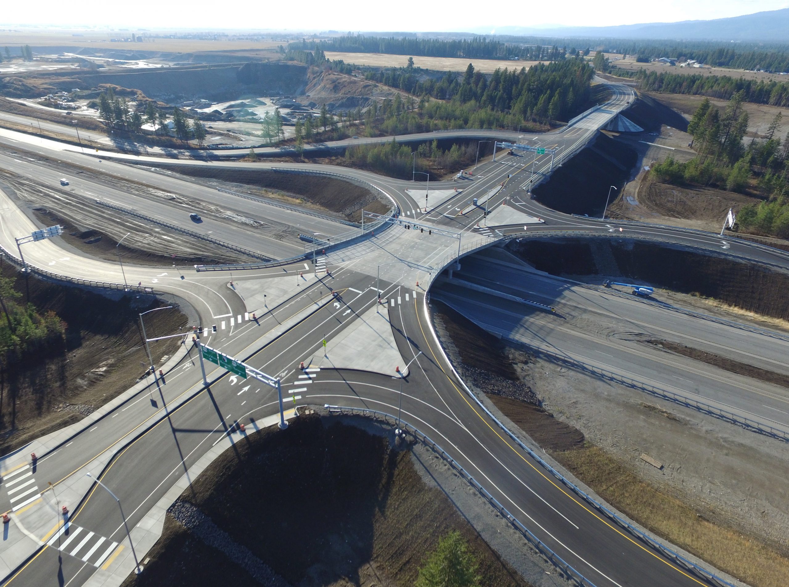
It’s called a single-point urban interchange, or SPUI (rhymes with “chewy”), and the first one in North Idaho was opened at the intersection of U.S. 95 and Highway 53 on Tuesday.
Whether it’s the new roundabout – a simpler, safer alternative that’s nonetheless the object of seemingly endless derision – or the next backup camera – a new design that drivers can’t imagine living without – remains to be seen.
And, ultimately, it doesn’t much matter, because there it is now, funneling traffic in Kootenai County, which is not exactly a hotbed of transportation innovation.
Last month, for example, voters overwhelmingly turned down a ballot initiative that would have imposed a $50 vehicle registration fee in order to pay for a suite of projects that area planners say are vital to catch up on the demands of a half-century of growth, not to mention the population explosion expected over the next two decades.
But the ITD has forged ahead with efforts to improve the strapped road infrastructure connecting Coeur d’Alene, Post Falls, Rathdrum and the unincorporated area where U.S. 95 and Highway 53 now come together at the SPUI.
Despite the novel name and the explanatory video, the interchange shouldn’t be all that hard for drivers to figure out. Like most highway interchanges, it includes an overpass and both on- and off-ramps.
In this case, Highway 53 crosses over the top of U.S. 95. At the center of the overpass sits a single set of traffic lights that control the flow of traffic above 95, with signals for east-west traffic on 53 and for traffic coming up the ramps from 95.
The lights at that single point will operate on three cycles. One will be for through-traffic on Highway 53. Another will be for traffic turning left from the 95 ramps onto 53. A third is for traffic turning left from 53 onto the 95 on-ramps.
The nearly $55 million project also involves changes beyond the bounds of the 95/53 interchange.
Since work began in July 2019, Highway 53’s approach to the intersection from the west has also been widened to four lanes straightened out, while Government Way, which runs parallel to 95 along the highway’s east side, has been extended to the north and signed as Pope Road.
But work is not done in the area.
In the spring, construction of an overpass at Garwood Road is slated to begin – and will require the closure of its intersection with U.S. 95 until the fall, requiring drivers to use the frontage roads and interchanges at Highway 53 or Chilco Road to bypass the area.
That will be a temporary disruption that ITD planners say will pay off with a not only safer, but also a faster, road network.
The speed limit north of Boekel Road is expected to increase to 70 mph, and a pair of traffic signals will be removed, making the light at Lancaster Road the last one for drivers heading from Coeur d’Alene to Sandpoint.
And drivers who get used to the next traffic pattern at U.S. 95 and Highway 53 will be ahead of the curve when the ITD moves to another phase of its work in Kootenai County: replacing the Interstate 90 and Highway 41 connection with another SPUI.
West Plains Connection receives state funding
A plan to build a new route connecting Spokane and Airway Heights got a big boost last week when the state’s Transportation Improvement Board awarded $2.5 million to make the West Plains Connection a reality.
The money will be used to begin the first phase of the project, which eventually will entail construction of a patchwork of new and improved roads and paths running just north, and mostly parallel, to Highway 2.
The first phase centers on filling in a section of 10th Avenue from Garfield Road to South Hayford Road in Airway Heights that doesn’t currently exist.
Though final design is not complete, a news release said the new route will include two travel lanes, a landscaped or hardscaped center median with turn lanes at major and future intersections, and a multiuse pathway with a sidewalk on the opposite side of the road.
When complete, the West Plains Connection will start near the city of Spokane’s western edge and pass through all of Airway Heights along 12th Avenue, 10th Avenue, Garfield Road and Sixth Avenue.
Work on Phase 1 is expected to begin in the spring of 2022.
Planners told the Spokesman-Review in September that they see the project as a mechanism for unlocking development and housing potential on a number of undeveloped parcels of land that the connection will pass through.
A news release about the funding for Phase 1 suggested “the corridor development could ultimately create more than 3,300 jobs with annual wages of roughly $132 million.”