Getting There: Airway Heights officials hope roundabout on eastern edge will help recreate a downtown
Airway Heights has a heart.
Rather, it had a heart, but it was run through with a highway.
As its name suggests, Airway Heights was founded in 1955 to serve the flyers and pilots of Fairchild Air Force Base and what was then called Geiger Field, what is now called Spokane International Airport and what had previously been Sunset Field. The original town center stood at the corner of 14th Avenue and Lundstrom Street, near where the Village Tavern and Exxon gas station sit. The West Plains town grew slowly, but quickly became what it remains today: a highway with a town on either side.
Now, the city’s leaders want that to change – or at least bring back some of the small-town, Main Street feel. And it begins and ends with a roundabout.
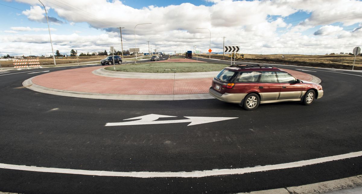
Last year, a multilane roundabout opened on U.S. Highway 2 on the city’s west side as part of the Spokane Tribe of Indians casino development. The circular intersection was a physical reminder that the city had begun, and motorists had to slow down. After some initial grousing, drivers got used to it.
This year, at the other end of Airway Heights on the freeway, another multilane roundabout will be built at the intersection of Deer Heights Road. The roundabout is technically in the city of Spokane, and the city is paying for the work, but the $1.5 million project was conceived and is being led by the West Plains Public Development Authority. That will make it somewhat difficult for people to find the right governmental entity to complain to, but we can all expect the grousing, as well as the getting used to.
In a separate, related project, the Washington State Department of Transportation is building a raised center median on the highway between the roundabout and Hayford Road, along with some turn lanes. Motorists on the highway will have opportunities to turn. Drivers hoping to turn left and head east out of the shopping center will have to use the light at Hayford.
The point of it all is to slow people down, decrease potential conflicts between drivers and their vehicles and generally make the road safer. The plan to do so has been in the works for 20 years, most recently approved in 2017 with Airway Heights’ U.S. 2 Corridor Plan, which “recognizes the importance of U.S. Highway 2 to its economic vitality and community image,” but notes that efforts over the past two decades to revitalize the city’s core have gone nowhere.
“Airway Heights’ town center continues to remain a priority for revitalization,” reads the corridor plan. “As the historic ‘heart’ of Airway Heights, future efforts will see a downtown plan and strategy for encouraging a lively center of commerce and community.”
Most people might have trouble pinpointing this heart of town with its imperceptible pulse, but it’s there. Fourteenth Avenue is, in fact, an old street that was once the city’s downtown. Historic photos show clusters of buildings on what is now 14th, at the service of motorists on the old Sunset Highway.
The road today is easily mistaken for an outgrowth of the parking lots for Rosa’s Pizza, the Scrub-a-Dub car wash and Yoke’s grocery store. As part of the corridor plan, the city wants to reinvigorate the old downtown, with new landscaping, better pedestrian facilities and other cues to passers by that there’s a city there.
More to the point, though, they want motorists to slow down. The city’s goals for the corridor include devising ways to “inspire travelers to stop,” “slow down traffic for safety” and “promote a healthy community through pedestrian and bike activity.”
Those might be hard sells. For most motorists, Airway Heights is U.S. Highway 2, their route on their way to the base, the airport, the casinos or Walmart. But it’s the popularity of the road and these destinations that have led to the need to fix the road.
In 2015, there were 59 crashes on the highway in city limits. In 2016, there were 79 recorded collisions along the corridor, and the number of collisions on the freeway has remained in the 70s every year since.
The worst spot of the road is its intersection with Hayford, the busy route to Northern Quest Resort & Casino. WSDOT says the intersection is operating “at or over capacity.” A map of collision data collected by WSDOT shows a bright cluster at the intersection in all four directions.
With the construction of the roundabout, the town will be bookended by them on U.S. Highway 2. The days of motorists traveling too fast on the busy corridor may be numbered.
But for regular commuters on the road – which sees upwards of 27,000 vehicles on an average day – who feel their dander rising, fear not. The highway isn’t going anywhere. It’s just getting a heart.
A public town hall on the roundabout project is being held from 4 to 6 p.m. Tuesday at the Hilton Garden Inn, 9015 U.S. Highway 2 West.
Corner of Sprague and Sherman closed
Major work related to the south landing of the University District Gateway Bridge begins today, and will close the intersection of East Sprague Avenue and Sherman Street to traffic.
Traffic will be detoured onto First Avenue via Grant and Hatch streets.
The project will create a transit hub for Spokane Transit Authority vehicles, whose routes travel on both Sprague and Sherman. It will also build some bicycle and pedestrian facilities on Sherman through the intersection. The $745,000 project will bring new signals and pedestrian lighting, and landscaping, to the intersection.
In the city
Work on the Adams Street stormwater and sewer tank continues to affect commutes. Beginning today through Friday, April 19, westbound Riverside Avenue from Jefferson to Cedar streets will be closed.
Traffic will be detoured south on Jefferson to Sprague. The project to construct the $16.3 million, 2.4-million gallon tank is nearly complete.
Also through Friday, the left northbound lane of Division Street from First Avenue to Spokane Falls Boulevard is closed, along with the westbound curb lane of Riverside Avenue.
Montgomery Avenue is closed between Ruby and Division streets through April 25.
The right-most eastbound curb lane of Francis Avenue will be closed from Myrtle to Havana streets beginning today through April 26.
The southbound curb lane on Ray Street will be closed between 17th and 22nd through May 9.
Crestline Street’s eastern lane will be closed between Brooklyn and Weile avenues beginning today through May 10.
Maintenance work on I-90, Highway 2
A major repaving project on I-90 begins today, and will lead to a reduction in speed limit for the duration of the project.
The work will occur between Ritzville and State Route 21, and will restore about 10 miles of the existing pavement through a grind and overlay maintenance work in the driving lanes and shoulders. The $6.27 million project will extend between the Lind and Ritzville interchanges.
Once the roadway surface has been milled, motorists must travel at a reduced speed limit of 60 mph until the project is complete in June. Drivers can expect single lane closures and short term, intermittent ramp closures.
Similar maintenance work will affect commutes on U.S. Highway 2 between the town of Reardan and Espanola Road.
The $2.2 million project, which also begins today in Reardan, will impact travel in the town through May 24. Motorists can expect lane closures and temporary intersection closures. Work outside of Reardan is expected to start May 13 and last through June 13. Drivers should anticipate flagged single lane, two-way traffic lanes, and pilot-car directed lane closures.