Decades after Mount St. Helens eruption, Pacific Northwest volcanoes still leave their mark
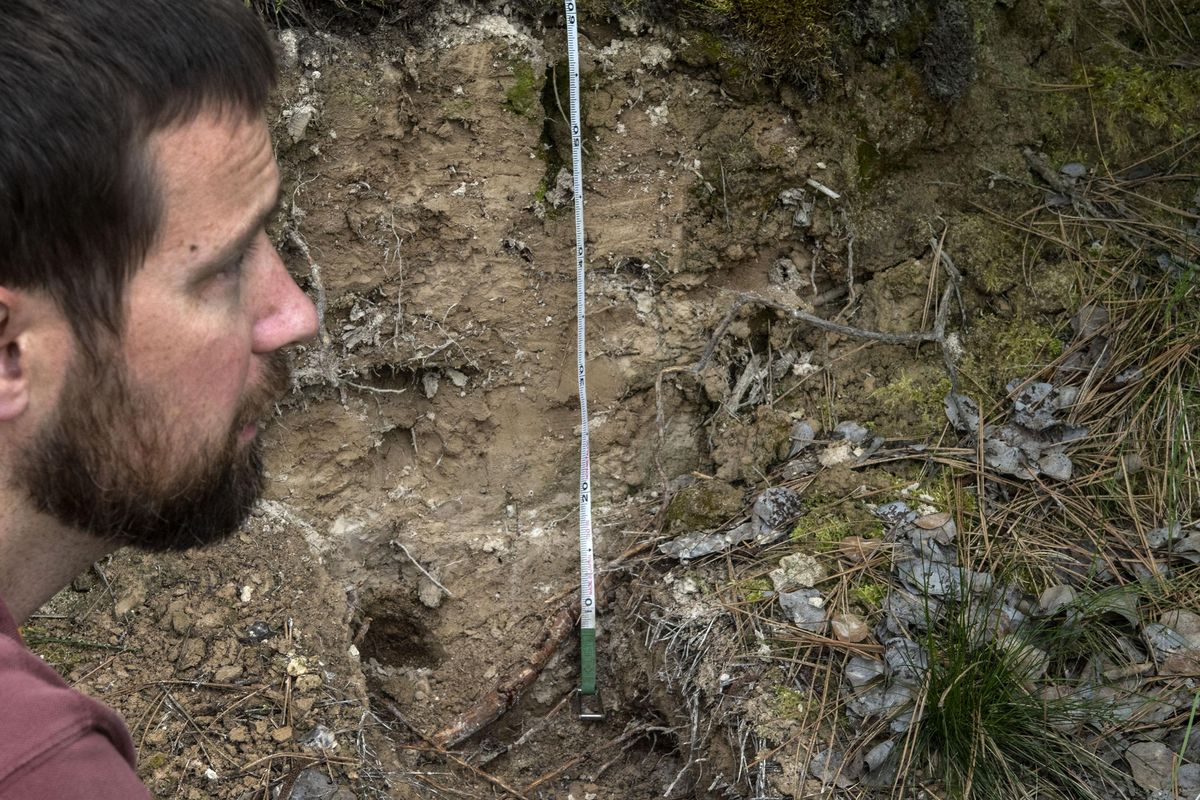
There’s a layer of white ash just under the grass and moss of a small bank near the Dishman Hills Natural Area.
It settled there after the Mount St. Helens eruption in 1980.
But the layer of soil below it might give better insight into Spokane’s history with volcanoes.
More than 3 feet deep, the light-colored soil is chalky and makes an uncomfortable scraping noise if you rub it between your fingers.
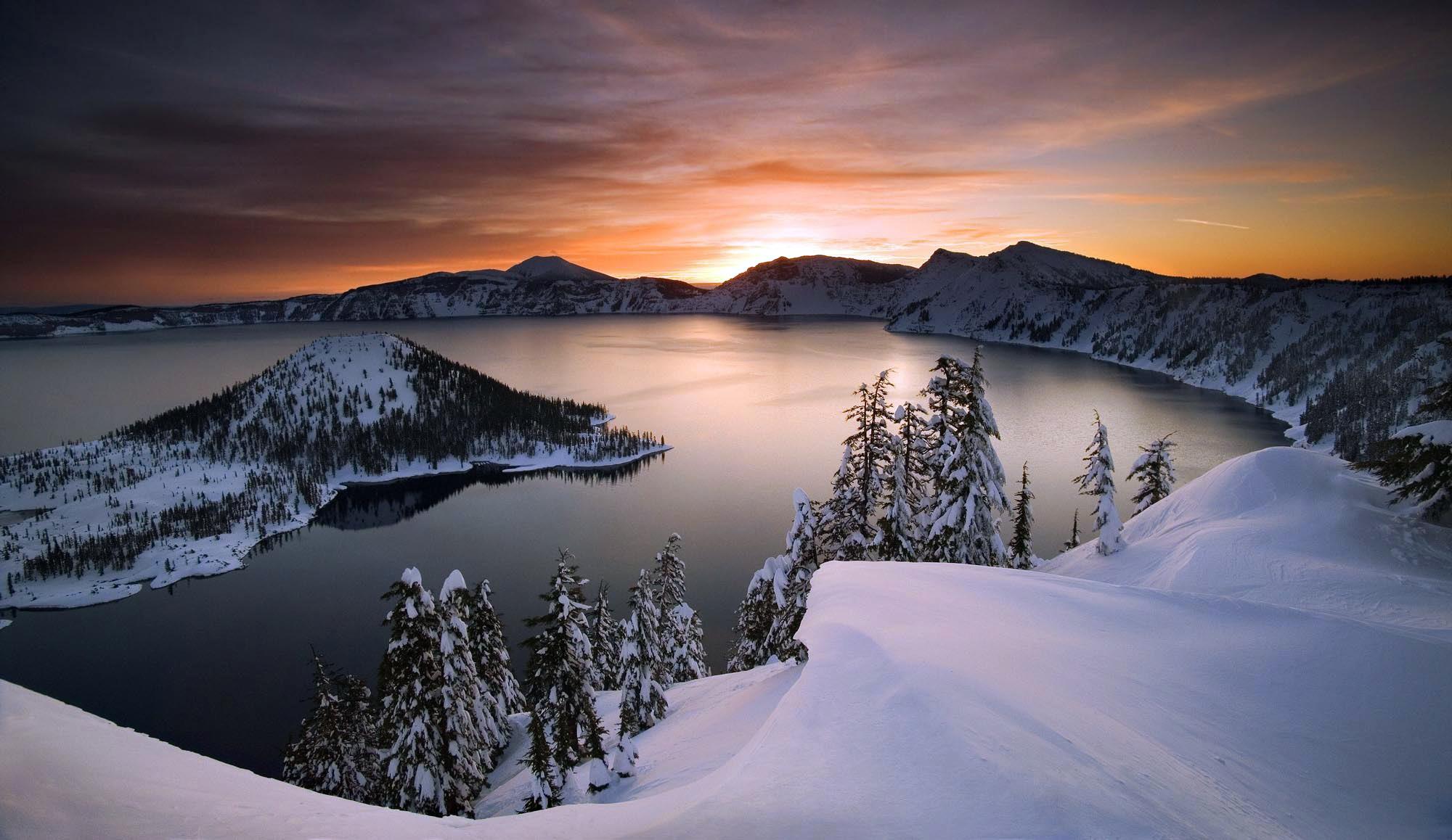
It’s ash from Mount Mazama, the caldera volcano that exploded so forcefully 7,600 years ago that the weight of the lava collapsed the mountain’s dome, creating Oregon’s famed Crater Lake, said Chad Pritchard, a geology professor at Eastern Washington University.
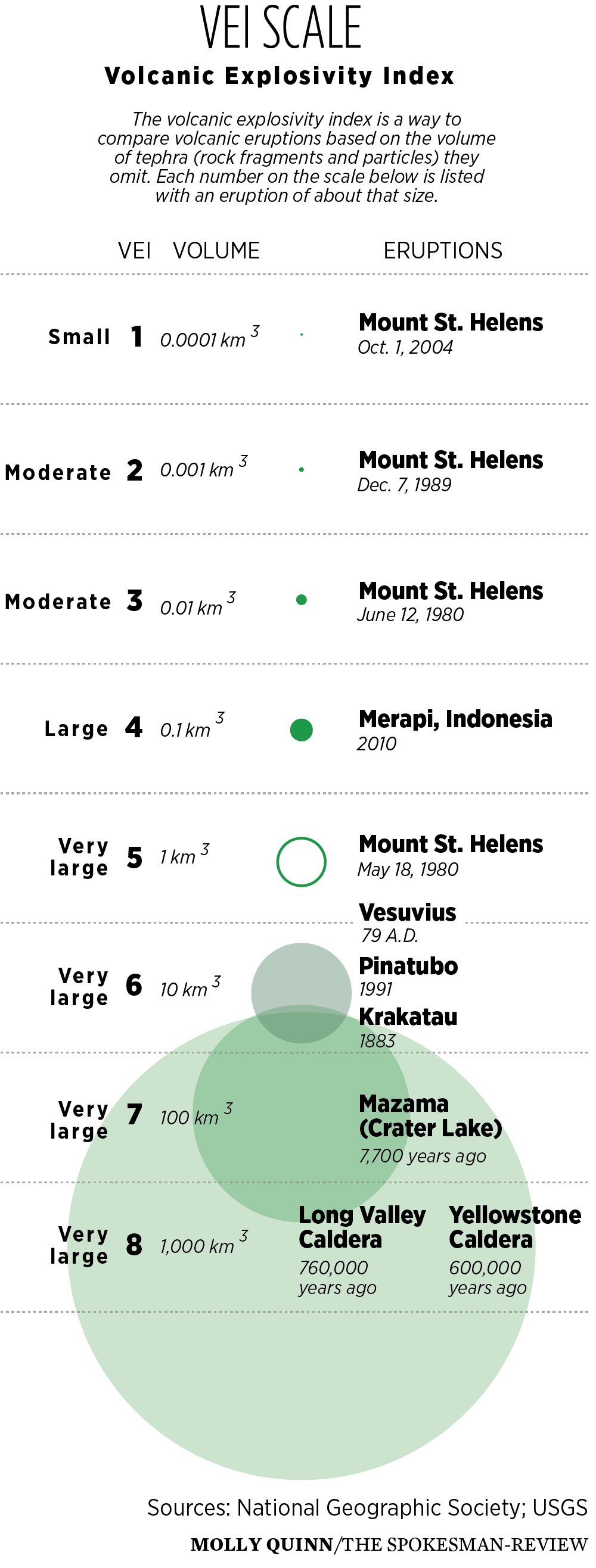
Geologists use a “volcano explosivity index” to measure the relative severity of eruptions, ranking them on a scale of 1 to 8 depending on the amount of material blown out of the mountain and the size of the plume.
On that scale, the 1980 eruption sits right between a 4 and 5, with about 1 cubic kilometer of tephra – the ash and other debris that erupt. Vesuvius, the famous eruption that buried Pompeii, was a 5, with about three times the tephra volume.
The explosion that gave us Crater Lake was a 7.
“St. Helens was a relatively small eruption in the grand scheme of things,” said Jennifer Thomson, chair of EWU’s geology department.
Washington celebrates Volcano Preparedness Month in May, coinciding with the May 18 anniversary of the Mount St. Helens eruption.
Scientists with the U.S. Geological Survey have been busy answering volcano questions on Reddit and encouraging the public to learn more about Washington’s most famous mountains.
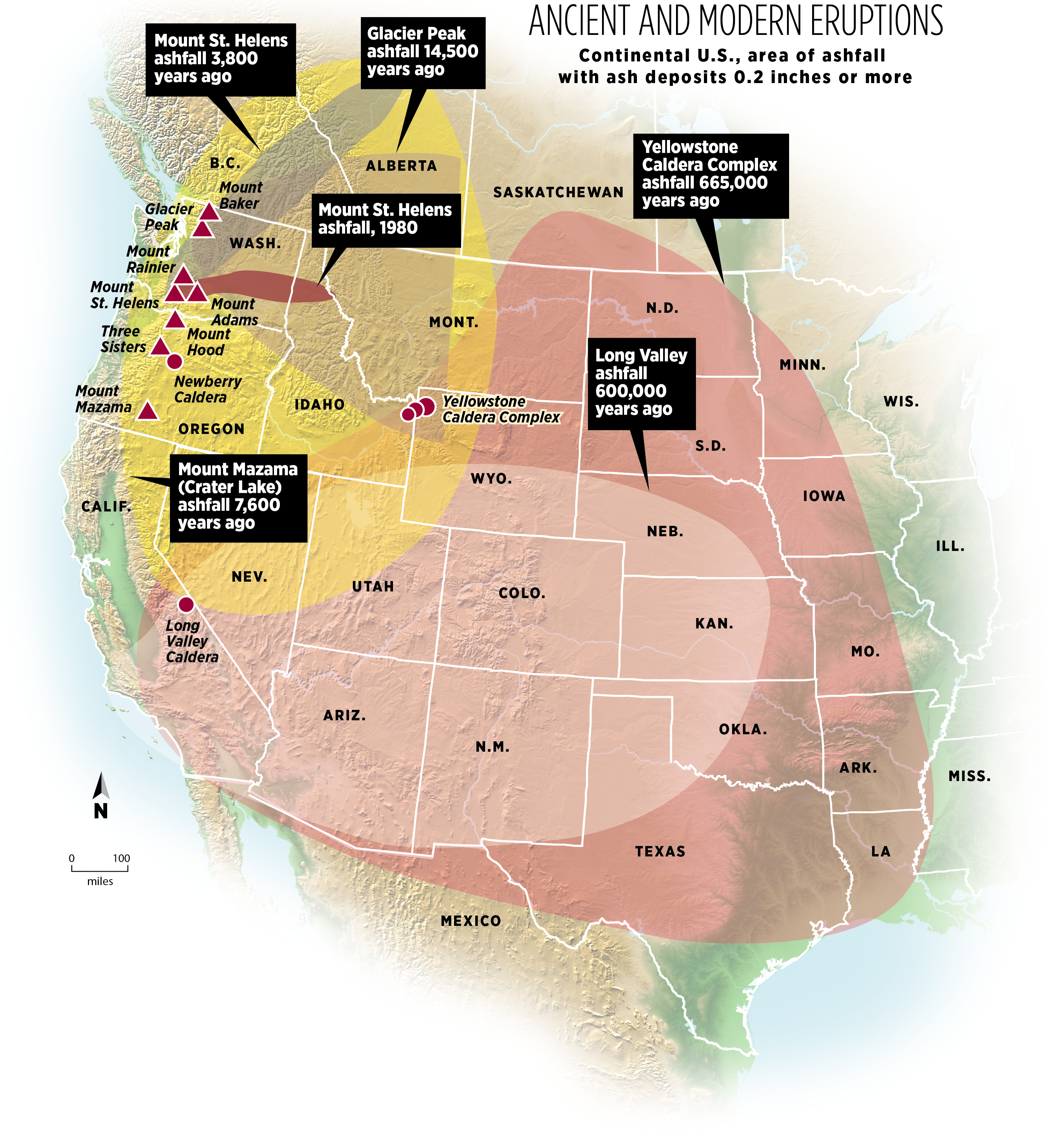
For those who lived outside the Northwest when the mountain blew its top, it’s easy to think of Spokane as removed from the volcanoes that surround it: the active Cascade range to the west and the infamous Yellowstone caldera to the east.
The Inland Empire is out of range for the immediate, deadly impacts of a volcanic eruption from either direction. We’re not going to be overrun by lava or lahars, the fast-moving and deadly flows that mix mud, ash and debris.
But we’re well within the ashfall zone for any of the region’s active volcanoes. As anyone who lived in Eastern Washington in 1980 can attest, ash is plenty disruptive on its own.
Mount St. Helens retrospective
Colin Mulvany
- The Spokesman-Review
When news of the eruption reached Spokane, the first thought of many was, “Thank God we’re hundreds of miles away.”
Within a few hours, people were forced to re-evaluate as a black cloud from the west drifted ominously toward the city.
The Spokane Daily Chronicle called it “Ash Sunday,” as an inch of gray dust covered Spokane and surrounding areas.
Ash blacked out the sun as far away as Missoula, and fell from the sky so heavily in Yakima that officials warned people to stay inside. Ritzville was buried in 4 to 6 inches.
With roads closed, shops shuttered, bus service slowed and flights canceled, “movement in general seemed to freeze in place,” the Chronicle reported.
Interstate 90 closed from Spokane to North Bend, and events, including a Dizzy Gillespie concert and an air show at Fairchild Air Force Base were canceled.
Some residents were confused about how an eruption 290 miles away could have such an impact.
People wore masks when venturing outside. Though the ash wasn’t toxic, it was gritty, prone to being kicked up by the slightest movement and clogging sewers and air filters.
Farmers initially feared the worst. So much was written about the potential and actual damage to crops that The Spokesman-Review’s archive carries a stack of clippings about crop impacts from the eruption.
By June 10, state agricultural officials estimated the damage at $200 million. The season’s first cut of alfalfa hay was gone, thanks to ash and heavy rains, and $10 million of lentils were lost. Carrots wilted under the high salinity of some of the ash.
Some wheat and potato crops were also destroyed.
But it wasn’t all bad. The 1980 season brought in a record wheat harvest and hops thrived in the ash.
In the Yakima Valley, orchardists used high-pressure hoses to rinse fallen ash off trees. Early reports suggested fruit was dropping off trees at the slightest touch, but agricultural associations said reports of the damage were overblown. Pear, peach and apricot production all increased that year.
Volcanic activity is partially responsible for the Palouse loess, the distinctive soil that has made southeastern Washington a fertile wheat-growing region. Many in the region took a long view of the 1980 eruption.
“Mount St. Helens has burped before and we’re still here,” said James Engibous, then-chairman of Washington State University’s agronomy and soils department, in a June 3, 1980 Chronicle article.
What about now?
Mt. Rainier is considered Washington’s most dangerous volcano because of its proximity to cities like Puyallup, which likely would be hit by lahars. But for Eastern Washington, it’s Mount St. Helens and Glacier Peak that are most likely to wreak havoc.
“Each of these volcanoes has its own personality,” said Carolyn Driedger, a hydrologist with the U.S. Geological Survey who works at the Cascades Volcano Observatory.
Glacier Peak and St. Helens tend to spew ash, she said, while Mount Rainier and Mount Baker produce less. They’re likely to have a more localized impact for people living in range of mud flows and landslides.
“People assume that the volcano that is closest to their community is the one that’s going to affect them the most,” Driedger said. But the differences in ash production mean that’s not necessarily the case.
Spokane is well outside the blast zone for any Cascades volcanoes, and for the Yellowstone caldera, Pritchard said. Regardless of the source of an eruption, the Inland Northwest won’t be vaporized.
If you missed out on the 1980 eruption, geologists want you to know that the ash from volcanoes is very different from the fireplace remnants the word usually evokes.
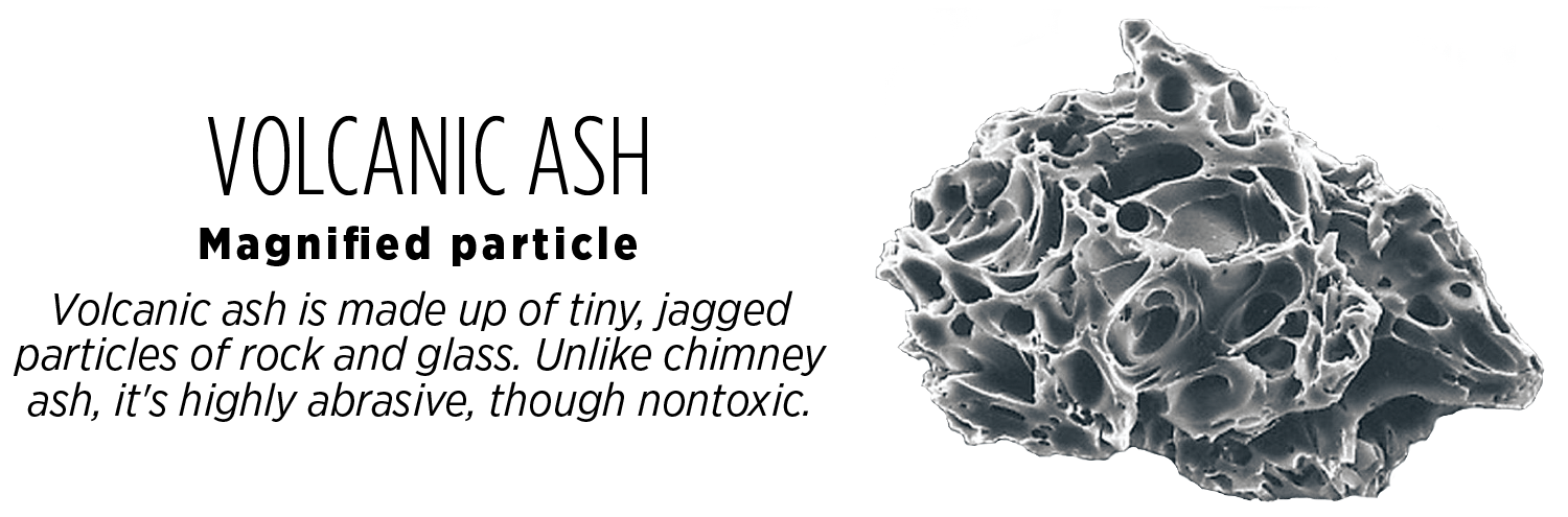
“Volcano ash consists of shattered pieces of lava that have been blown apart,” Driedger said.
“It’s actually glass fragments that are very, very small,” Thomson said.
Ash will cool and won’t burn people. It doesn’t contain volcanic gases. In small doses, it’s a nuisance. In larger falls, it can collapse buildings and power lines.
For Eastern Washingtonians who aren’t at risk from lahars or an actual blast, being ready for a volcanic eruption mostly means having supplies. Ash can contaminate drinking water, so the Washington Emergency Management Division recommends storing ample water alongside food and other supplies.
And in the aftermath of an eruption, people should mostly stay inside, use masks to protect breathing, and minimize driving, since ash easily clogs cars.
The St. Helens eruption was a stark display of the raw power of nature. It’s the reason scientists like Driedger like studying the dangerous mountains that have the ability to grind daily life across the state to a halt.
“It’s kind of senseless to try and control nature,” Driedger said.