Networking nature

FORT EDWARD, N.Y. — Lowered into a muddy stretch of the Hudson River, the unmanned submarine dove through the murk and zigzagged downstream, meticulously collecting information on the water’s condition and transmitting it to scientists.
The robotic explorer, powered by sunlight and navigating on its own, took only a test run, but researchers hope vehicles like it will become part of a river-wide network of sensors that provide constant, real-time data on spills, fish migrations and other aspects of the river’s ecology.
The embryonic Riverscope network is one of many so-called sensor webs for monitoring the planet’s ecosystems, from ocean currents to mice scurrying across corn fields.
“We’re talking about a bold new world of information that would give scientists a quality and quantity of data that they’ve never had before,” said John Cronin, executive director of the not-for-profit Beacon Institute, which is developing Riverscope as part of its mission to study rivers and estuaries.
Data collection is as old as science, but Riverscope and similar systems allow information to be collected and quickly analyzed from many points over a large area. By increasing the number of data points, scientists are able to get a clearer picture of what’s happening.
Data from the remote sites are automatically fed into computers — there’s no need for researchers to visit to each location.
In the case of an oil spill, researchers could tap into a network of chemical sensors already in the water rather than taking samples from a boat. Another set tracking water flow could help predict where the oil will spread.
Riverscope started in 2004 with five shoreline sensors measuring conditions like flow, pressure, temperature and turbidity along a 130-mile stretch of the Hudson. The stations are maintained by Rensselaer Polytechnic Institute and Columbia University’s Lamont-Doherty Earth Observatory.
Cronin said the river will become more plugged in over the next five years, though it’s not yet clear whether it will be through fiber-optic cables, wireless technology or some combination of the two.
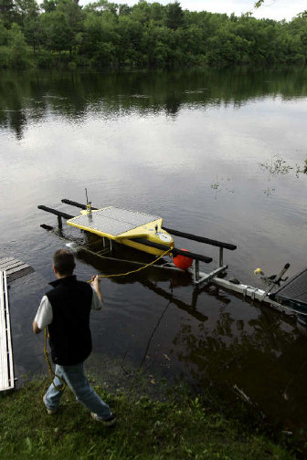
He expects the roving, autonomous submarines to fill the gaps between stationary sensors. The craft, which move as fast as 3 mph and withstand ocean conditions, can run continuously for months thanks to solar panels attached to the wings of the 7.5-foot, torpedo-like body.
The model tested on the river last month was fitted with sensors for salinity, temperature, pressure, oxygen and chlorophyll.
“You could have it running from Albany to New York City on a regular basis,” said Art Sanderson, a professor of electrical, computer and systems engineering at RPI. He said the per-vehicle cost of $100,000 would decrease as more are purchased.
The federal government has shown interest in sensor networks, with the National Science Foundation helping fund Riverscope and a number of similar projects.
Most are in the early stages.
They include Earthscope, based on geophysical data, the Ocean Research Interactive Observatory Networks (ORION) and the National Ecological Observatory Network (NEON), which will focus on “ecological forecasting” of land use changes and species migration. NEON sensors will be placed high on towers, in the soil and on animals as small as deer mice.
“We will be able to follow the position of hundreds of animals simultaneously,” said James MacMahon, a NEON scientist who heads the Ecology Center at Utah State University.
It’s no coincidence that so many plans are progressing at once, given advances in miniaturization and wireless communications. Transmitters can now be made small enough to fit on a locust, MacMahon said.
The capabilities of networked computers have become more sophisticated, too. The massive amounts of data collected by these projects can be run through a linked grid of computers instead of a single machine.
“It probably couldn’t have been done 10 years ago, and now we have the grid computing capabilities that are ripe for doing this,” said Jami Montgomery, executive director of the Collaborative Large-scale Engineering Analysis Network for Environmental Research.
Sanderson said the Riverscope network could be configured to track invasive species like zebra mussels, or PCBs kicked up from the planned dredging of the upper river. Cronin said the network could pinpoint times when freshly spawned fish are passing by powerplant water intakes, giving operators a chance to respond.