State may remove busy I-90 eastbound on-ramp at Walnut in downtown Spokane
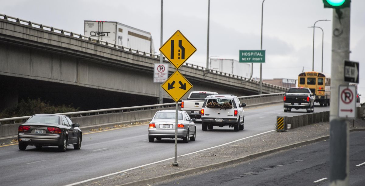
Without the interstate at its end, the eastbound Walnut Street on-ramp might seem like a jump.
A platoon of motorists sits at the red light, their collective engines revving, readying for a race to the top of the 250-foot ramp. Uphill, pedal down, in hopes of reaching highway speeds in time.
It’s really not the best way to 60 mph.
Which is why that on-ramp may go offline in the near future. That’s right, the Walnut ramp is slated for closure.
A recent study looked at collision data on Interstate 90 between Four Lakes and the Idaho border, and it identified the Walnut ramp as the most dangerous point in the area of study. The study was part of a larger operations and safety analysis done by the Washington State Department of Transportation.
“We looked at all the crashes or collisions that are happening on this whole corridor,” said Glenn Wagemann, a traffic engineer with transportation department. “We saw more in the urban core. And Walnut jumps out as the location with the highest number of collisions.”
From 2011 to 2015, there were 10 fatal crashes and 30 more causing serious injury along the 30-mile corridor. In the same period, the Walnut ramp saw 98 rear-end or merging crashes. In a distant second, the westbound Maple Street on-ramp saw a quarter of that, with 26 crashes.
Wagemann said the Walnut closure wasn’t exactly a sure thing, but he couldn’t see another solution to its dangerous nature. Regardless, any closure wouldn’t happen for years because its repercussions need to be studied further.
The state plans to study the issue further with the city of Spokane and Spokane Regional Transportation Council “to look at how to utilize the network we have without adding additional capacity,” he said. “There’s really no timeframe.”
In other words, city, state and regional transportation planners are going to see if the city’s other roads, and the highway’s other on-ramps, can handle the increased traffic when Walnut goes dark.
The Spokesman-Review
Wagemann, for one, said they can.
“We’ve done enough analysis to show that the city network can support it,” he said.
Walnut has an average daily traffic count of 11,000 vehicles. Monroe, near its on-ramps, sees half that. Wagemann said the traffic diverted from Walnut would move along Third and Fourth avenues to the eastbound Monroe Street on-ramp, which had just 13 crashes in the five years the study analyzed.
The Monroe ramp is safer than Walnut for a number of reasons, Wagemann said. First, its corkscrew turn forces drivers to keep their speed down until they reach the interstate’s merging lane. And unlike Walnut’s 250-foot race to the top, Monroe has a 3,000-foot “weaving” lane, allowing drivers to get to speed while merging with traffic, some of which needs to get over to exit at Division.
“We have the data to support it, but we have to educate along the way,” Wagemann said of the closure. “It’s not a great impact in your commute. It’s not really going to change your travel time. But when you talk about it from a business standpoint, some of the businesses rely on that traffic pattern.”
Other fixes are coming to I-90 much sooner than the Walnut closure in an attempt to increase the highway’s safety. The state transportation department has $4.4 million to spend to reduce the number of crashes on the corridor, and motorists will begin to see them in place by 2019.
Notably, a ramp meter likely will be placed on the interchange connecting U.S. Highway 195 to eastbound I-90, which has seen booming traffic thanks to the growth in population in the Latah-Hangman neighborhood. The meter will be alternating red light, green light to break up merging traffic during rush hour.
The transportation department will also install wrong-way driver notification signs along the interstate, which will only be activated when someone drives against the flow of highway traffic.
Lastly, the transportation department will invest in more incident response teams in order to clear crashes within 15 minutes, reducing the odds of a secondary incident. For every minute the roadway is not cleared, the chances of another crash increase by 3 percent, according to the transportation department.
Once those are complete, the Walnut on-ramp hits the chopping block. Until then, Wagemann urged motorists on the ramp to give each other more room.
“Don’t come onto the freeway in a platoon, with 10 cars trying to get into a one-car-length gap,” he said. “Allow for the zipper.”
Have a transportation question you want answered? Write nickd@spokesman.com.
Riverside opens to traffic
Westbound Riverside Avenue is open to traffic after a closure related to the Adams Street Combined Sewer Overflow project, part of the city’s effort to completely stop sewage from entering the Spokane River. Riverside will act as the detour route for the continued Sprague Avenue closure.
The project continues to impact traffic and parking just west of downtown. Adams between First and Sprague avenues is reduced to one lane and there is no on-street parking. First is reduced to one lane eastbound, with no on-street parking from Cedar to Jefferson streets. Sprague is closed to all westbound traffic from Jefferson to Cedar. Eastbound Riverside is closed from Cedar to Jefferson.
The $16.3 million project is constructing a 2.4-million-gallon tank and other infrastructure and is paid for with the city’s utility funding.
Farther east, the construction of another sewage tank is closing the intersection of Riverside and Magnolia Street on Monday. This closure will only affect the intersection and will be complete Nov. 3. Access to local businesses and residences should remain available during this period.
Ramps on Assembly
Crews will install curb ramps on Assembly Street from Nine Mile Road to Winston Court. Motorists can expect obstructions.
Crestline lane reduction continues
Work to reduce the number of lanes on Crestline Street between Euclid and Francis avenues goes on. Southbound traffic is reduced to one lane between North Foothills Drive and Empire Avenue. When this work is done, crews will move to the northbound lanes from North Foothills to Empire, and eventually to the section from Empire to Wellesley Avenue.
The $510,000 project will be complete in late fall and will include lane striping and sign installations.
Division Street Gateway in final phase
The $3.5 million project to beautify the Division Street offramp and corridor into downtown Spokane is nearing completion. The work includes utility and stormwater updates, asphalt patching, curb and sidewalk replacement and landscaping.
On Tuesday between 6 a.m. and 3 p.m., the westernmost northbound lane on the Division offramp will be closed for utility vault work.
Downtown Howard to close for crane
Walker Construction will be completely closing Howard Street between Main Avenue and Spokane Falls Boulevard on Tuesday through Friday for crane use.
Minor maintenance
Bridge crews are painting on the Hatch Bridge from 9 a.m. to 3 p.m. Drivers can expect flaggers and delays.
Crews are sealing cracks on Second Avenue from Maple to Arthur streets.
Grind and overlay work on Buckeye Avenue between Division and Ruby streets will cause lane closures and delays.
City crews continue to fill potholes, but only if they know where they are. Report potholes to the city’s 311 pothole hotline or by calling (509) 625-7733. The largest holes on the busiest streets are priority.
Skin patching work on Market Street from Upriver Drive to Euclid will be done, depending on the weather.
In the Valley
Argonne Road between East Indiana and East Montgomery avenues will have intermittent road closures for a paving project Tuesday through Friday, from 7 p.m. to 5 a.m. Flaggers will be on site.
A road and sewer project on Barker Road at its intersection with Euclid has fully closed the road through Oct. 25. Local access is available on Barker north and south of Euclid.
Euclid between Tschirley and Barker roads is still closed for a road and sewer project until Nov. 9. Detour signs are posted and local access varies depending on excavation location.
The northbound curb lane on Sullivan Road’s northbound bridge will be closed on Tuesday between 6 a.m. and 5 p.m. for a bridge inspection. Signs will be posted to direct traffic around the work zone.
Pervious gravel is being installed on the shoulder of Fourth Avenue between Bowdish and Evergreen roads; Eighth Avenue from Pines to Adams roads; Flora Road from Valleyway to Broadway avenues; and Sprague from Barker to Holiday roads. Work will be Monday through Friday, from 8 a.m. to 5 p.m., and single lanes will be closed.
Highway 2 pavement
U.S. Highway 2 from Deer to Colbert roads is getting paving and turn lane improvements. Expect nighttime lane closures on Highway 2, state Route 206 and Day Mt. Spokane Road. Nighttime traffic on Highway 2 will be reduced to one lane each direction from south of Deer to north of Colbert from 7 p.m. to 6 a.m. Westbound traffic on Route 206 near the intersection with Highway 2 will be reduced to one lane at night. Westbound traffic on Day Mt. Spokane Road near Highway 2 will be reduced to one lane at night. Daytime shoulder closures and lane shifts may be in place.
Asphalt on I-90
Both directions of I-90 may be reduced to one through-lane at work locations between Sprague Lake and Fishtrap for asphalt paving. Work is now scheduled during daytime hours, seven days a week.
Regional transportation plan open for public review and comment
The Spokane Regional Transportation Council’s long-range transportation plan, Horizon 2040, sets forth how the area transportation system will develop between 2018 and 2040. The plan recently has been updated with new goals, strategies and programs. It includes $9.9 billion in projects.
The council is responsible for doling out federal funding for regional projects. It is federally required to update its long-range plan every four years. It bases its plan on projections for population growth, housing and jobs and looks at all modes of transportation, including private vehicles, public transit, bicycling, walking, freight movement, air and rail.
They’ve done their work. Now it’s the public’s turn.
The plan is available for public review and comment through Nov. 12. It can be viewed at www.srtc.org or by calling (509) 343-6370 for a hard copy. Comments can be submitted by emailing contact.srtc@srtc.org.