Getting There: High Drive redo echoes vision of its early planners
From forested parkway to South Hill “highway,” High Drive has been it all.
When the minor neighborhood arterial opens in the next week or so, it begins its next phase of being as a multiuse corridor busy with motorists, runners, cyclists, dog walkers and people parked on benches enjoying the view.
In other words, the road will be something like how it was envisioned more than 100 years ago, when the Olmsted brothers came to town.
Spokane’s General Plan of the Park System was created by the Olmsted Brothers, a landscape architecture and urban planning firm with a direct linkage to Frederick Law Olmsted Sr., who was responsible for New York’s Central Park, the U.S. Capitol Grounds and the famous Chicago World’s Columbian Exposition in 1893.
Though representatives of the company came to town in 1907 and 1908, their report, which earned them the princely sum of $1,000, was published in 1913. If you’ve never heard of the park report, you have now. Spokane’s vast and varied park system is largely thanks to the pocket-sized report. Name any park in Spokane, and its story can likely be traced to this report, in one way or another. Manito, Cannon Hill, Palisades, Riverfront.
Another aspect of the report, one that is generally unknown, deals with the city’s street design. And it is one of the finest examples of what the Olmsteds proposed in Spokane High Drive, the city street that has undergone a renovation of the last five years that is nearly complete.
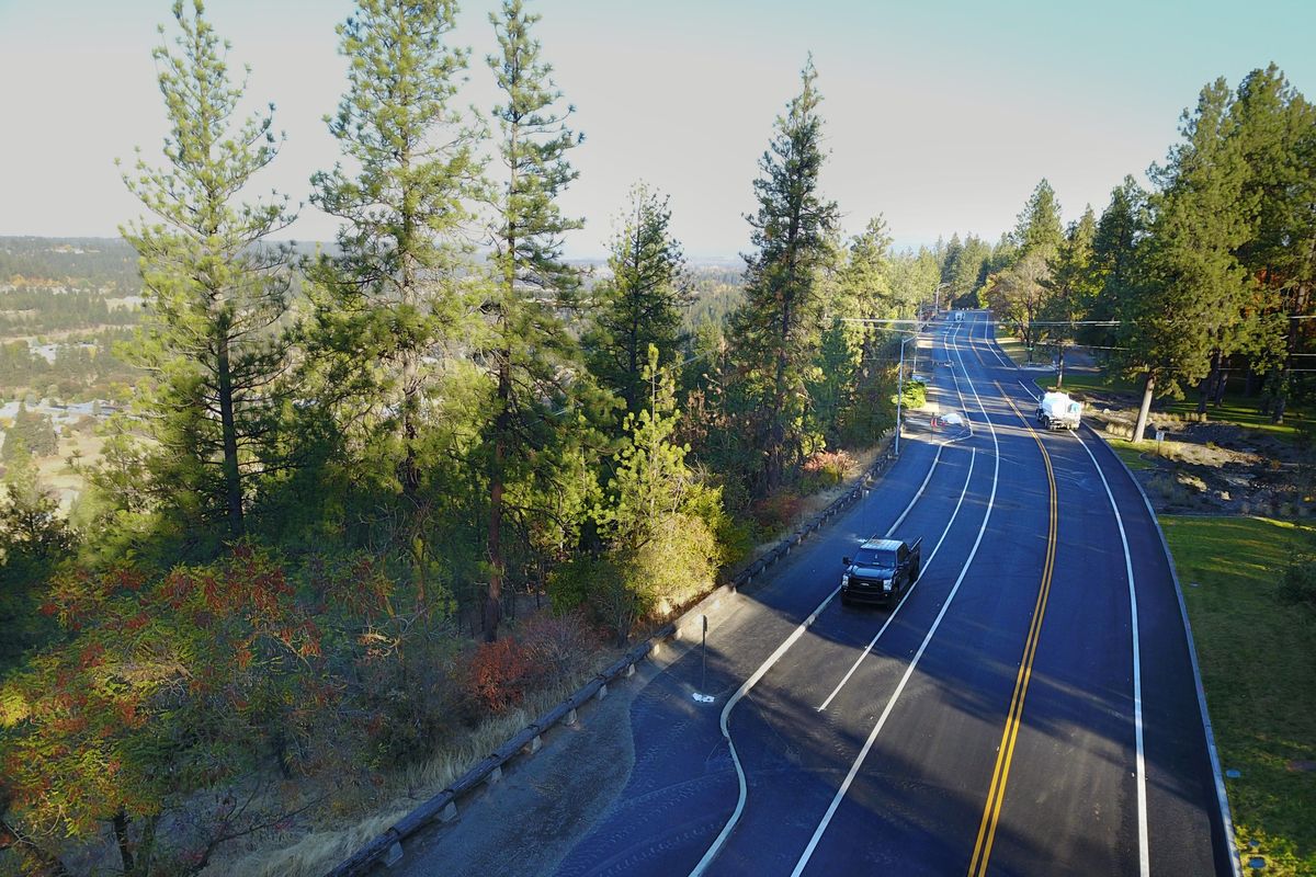
Beginning in 2013, the South Hill’s High Drive has been completely transformed by an $8.5 million city project. Vehicle lane widths were reduced, bike lanes were added and a wide, paved trail now flanks the road on the side with the money-shot and selfie-worthy views, from 21st Avenue all the way to Manito Boulevard.
This weekend, the city will open the final, reworked stretch of High Drive, from 21st to 29th. It will also open the Maple-Walnut-Cedar section of the commuting corridor, which has also been closed for pavement maintenance, foiling countless motorists.
In their report, the Olmsted brothers proposed High Drive Parkway as a “picturesque driveway lying on the high bluff in the southwest portion of the city, overlooking the Latah Creek valley.”
The parkway was part of network of roads the Olmsteds viewed almost as parks unto themselves, describing them as “roads specially fitted for pleasure driving and walking.”
The report proposed both “boulevards” and “parkways,” differentiating between the two by defining boulevards as “formal in character” and parkways as “more or less informal.” Both, it said, should have a “distinct quality of luxury and width and beauty of turf and trees.”
Still, the report was adamant that parkways and boulevards were different than ordinary city streets. For one, parkways must have “some landscape feature or naturalistic landscape gardening.” And don’t even get them started on boulevards.
“It is an abuse of language to call a street of ordinary width a boulevard,” the report admonished, noting that a boulevard must have at least four rows of trees, not two, like common residential streets.
According to nomination documents to the National Register of Historic Places for High Drive Park, parkway and Hangman Park, 112 acres were purchased in 1913 – the same year the report was published – for the parkway and park for a total of $51,453.45.
Though the parkway was improved some at this time, it remained in a “wild, forest-like state.” While it was still barely a “driveable roadway,” the parks superintendent at the time, John Duncan, said it would someday “be one of the most sightly driveways of the system.”
By 1918, a “fully developed road” appeared on city maps, stretching 1 1/2 miles from 25th to Division.
By the summer of 1930, the commuters of Spokane had taken to the automobile. The number of people who rode on Spokane United Railway’s streetcars started to decrease in 1915, but it plummeted by 33 percent between 1922 and 1933.
High Drive was just one of the many routes this new horde of drivers enjoyed. The expansive view was the main draw, but so was the undeveloped forest that still existed beyond 29th on the South Hill.
But motorists’ joy can quickly turn tragic, and High Drive posed a unique threat.
On July 18, 1930, the Spokane Daily Chronicle ran an editorial headlined, “Make the High Drive Safe – Now.”
“Now that tragedy has opened her eyes, Spokane can see the need for one street improvement about which there should be no delay,” the editorial read. “A guard railing must be built on High Drive.”
The Chronicle’s cry for improvement followed a “disaster” on the “highway that skirts the hill” where a car filled with five people “plunged over the 300-foot embankment.”
“The vista which opens to the eyes of the automobile driver along this highway offers temptation to take attention from the road and if this is done, even momentarily, the result is likely to be disastrous,” it read. “The same thought applies to every scenic drive in Spokane where high ground is unguarded. The same temptation to take the eyes from the road is there. The same tragic consequences loom.”
Almost as if to prove the editorial writer’s point, just 12 days after the column ran in print, a car with a pregnant woman inside drove over the bluffs. She and her unborn child died.
A community debate broke out. Some argued that guardrails were incompatible with the natural beauty of the vista. Others said the natural beauty was indeed a distraction for motorists, and therefore a guardrail was necessary.
Advocates of the guardrail won, and fencing was installed. The view that made High Drive one of the best road trips in town was considered lethal, and motorists needed protection.
Guardrail in place and the automobile continuing its takeover of the American transportation system, High Drive drew even greater numbers of motorists. Soon traffic engineers called for, and built, a longer, wider road.
By 1938, the road was “greatly widened,” according to the Spokane Daily Chronicle, and by 1952, the parkway stretched nearly 3 miles from 21st to Hatch Road.
Thanks to this expanded roadway, not to mention the middle-class wealth that came to the nation after World War II, untouched portions of the South Hill forest that had slowly been turned into neighborhoods were now swiftly developed with new housing and roads. In turn, this growth led to a need for a better High Drive.
Between 1968 and 1972, about $1.13 million was spent improving the road. Before this, the four-lane Cedar Street turned into the old, two-lane High Drive. Following the work, High Drive was now also four lanes. The original vision of High Drive as a pleasant jaunt for walkers and motorists in the Olmsted plan was obscured. The road that should’ve been “specially fitted for pleasure driving and walking” was just another route home. The view was good, but the real goal was traffic flow.
Years passed, potholes formed and the first reason for High Drive – as a parkway – was forgotten.
Until 2013.
Driven by deteriorating pavement and a need to stop stormwater from coursing off the oily street and into Latah Creek, the city set forth on a plan to rework High Drive. The “highway that skirts the hill” would become a parkway again.
When the lower, northern portion of High Drive opens in coming days, nearly the entire length of the road will be something closer to what the Olmsted brothers envisioned more than 100 years ago. The multiple uses of the pavement give it a parklike feel, and the view remains one of the most stunning in the city.
Once again, it will be a pleasurable drive or place to walk. Not a tragic speedway coursing on the edge of the South Hill.
Palouse Highway hit
The Palouse Highway is closed from 57th Avenue to 61st Avenue for construction related to the county’s Palouse Highway Sidewalk Project. Work is aimed at improving the Palouse Highway and sidewalks, and will include excavation, storm sewer, sidewalk, curb ramps and plantings. Work is expected to be complete by the end of November.
In unrelated work, city crews will start working on a grind and overlay project on the Palouse Highway from Regal to Freya streets.
Another city project has closed lanes on the highway from 55th to 57th avenues. The city expects the road to reopen Friday.
In the county
Spokane County pavement replacement work is affecting a number of commutes:
In the south, Regal and 57th is expected to be closed through the month of October.
Up north, Whitworth Drive is closed from U.S. Highway 395 to Wall Street for pavement and striping work.
Hamilton ramp
Work on the Interstate 90 Hamilton westbound on-ramp continues to keep the ramp entirely closed to traffic.
The $1.43 million project, which began in July, is anticipated to wrap up this month.